

Chase 2023
Target: Manhattan, Kansas
This day started out highly conditional with numerous targets in play. The primary target was in central Kansas, where a dryline was expected to bring some scattered storms. The secondary target was in central and southern Iowa. Initially due to the conditional threat of storms on the dryline I started in northern Missouri. However, as the day unfolded I quickly changed my focus to the original central Kansas target. I took HWY 36 westward out of St. Joseph and ultimately made it back to the south in Wamego when storms initiated in the early to mid afternoon. The first storms initiated about 5:30 pm along the dryline just north of Wichita. As I dropped south of Junction City on HWY 77 I encountered stiff outflow from these storms as well as impressive outflow driven dust clouds. These outflow winds caused me to run east a little to stay ahead of the strong wind. Once I got to Alta Vista I noticed a new developing supercell coming off the dryline in the same place as the previous storms. So, I let the initial storms go east, and I dropped south toward Cottonwood Falls on HWY 177. The maturing supercell was holding together as it moved toward Cottonwood Falls, so I stopped near Strong City, at the HWY 177/50 intersection and watched the storm approach from the south. As it approached it was high-based and somewhat skinny, but it was producing very large hail. After about 30 minutes, I dropped south through Cottonwood Falls and noted amazing structure. While taking some initial structure shots just south of Cottonwood Falls the RFD started to form. Since I was in some trees in the Cottonwood River Valley I moved north on HWY 177 and stopped near a nature preserve between Cottonwood Falls and Strong City. Here I watch it form a truncated tornado just west of Strong City. The funnel itself was constant, but the ground circulation was likely intermittent as it moved just north of Strong City. Once it cleared HWY 50, I moved north, through Strong City and found a well formed tornado just north of HWY 50. It was getting dark at this time, so it was tough to keep track of the tornado as it occluded north into the rain. A new circulation formed just south of HWY 50 and crossed about 3 miles ahead of me. I noted this on radar, and stopped short until it cleared the highway. As I proceeded east, I noted a well developed tornado from this second circulation just north of HWY 50. Again, with darkness settling in and the northerly tornado motion it disappeared quickly. I continued to parallel the storm along HWY 50 until I reached the western edge of Emporia. Here I photographed some structure and lightning before ultimately letting the storm go and heading home on I-35.
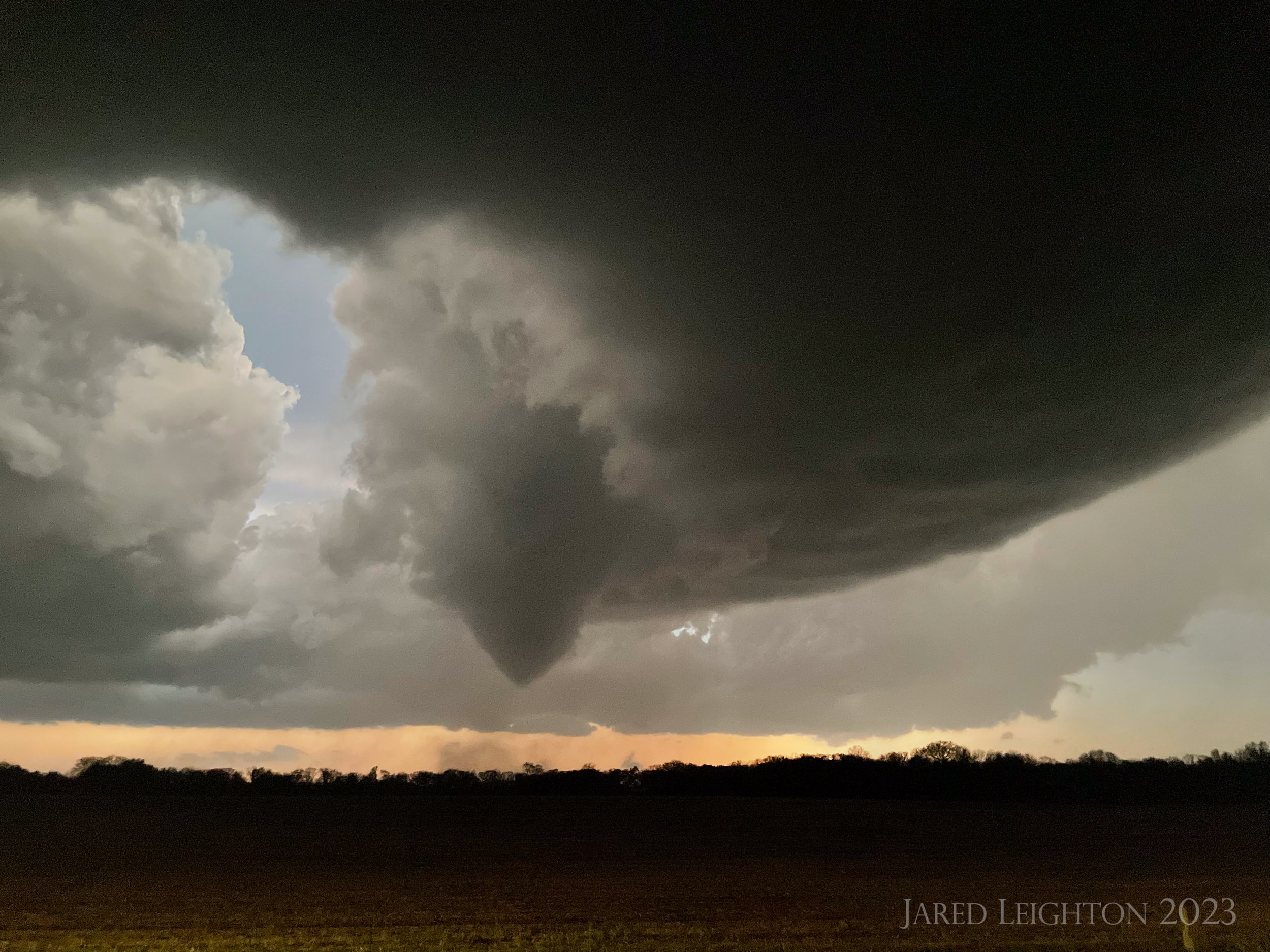
Developing tornado, looking west from Cottonwood Falls, along HWY 177
Target: Albany, Missouri
A short, impromptu chase based on late afternoon trends took me to northern Missouri. An area of supercells was developing around Tarkio, and was expected to drop southeast toward Chillicothe through the evening. I arrived to the base of the mature supercell around Stanberry, Missouri along HWY 136. As the storm dropped south, I got behind it, so I trailed the rotating storm southeast to around McFall Missouri. Along the way it was close to producing a few tornadoes, but never totally was able to accomplish tornado genesis. As the storm approached I-35 a trailing supercell formed and ultimately killed the main storm. This trailing supercell went on to produce large hail and a large tornado just north of HWY 36, through Linn County Missouri. With fading light and poor road network, I dropped all the way to HWY 36 and pushed eastward toward Brookfield. Finished the chase just southeast of the storm in Laclede, Missouri as it got dark and the storm started its downtrend.

Supercell near Albany, Missouri
Target: Slapout, Oklahoma
This day started out with moderate expectations with isolated to scattered convections anticipated in or near the Oklahoma panhandle region. Initially we targeted Slapout, Oklahoma, which is to say the intersection of Highway 412 and 162 Road just west of Beaver, Oklahoma. After stopping at Highway 412 and Highway 83 for a while we saw initial convection going up to our west near Hardesty, Oklahoma. We moved west from our location along HWY 412 and watched the cell rapidly mature into a supercell. Noticing it had some maturing still to do, we retreated back to the east and ran north on Highway 83. We watched as it made an attempt to occlude the updraft. Seeing we were running out of road options east of Highway 83 we proactively went east on EW Road 18. This road took us a little north of our easterly road to EW Road 15. We saw great motion on the underside of the updraft, but the base was a bit high for production. While watching that updraft perform we were getting isolated and sporadic golf ball sized hail at that location. To our north, not far from where we were we could hear large hail roar in the adjacent field. When we decided it was time to move east with the storm we noted a northward jog in the road, which would likely take us into the large hail. Unfortunately this was the only route east, into Beaver. Once we jogged north to road EW 14 into Beaver we encountered extremely large hail, which we estimated to be well over 5 inches in diameter. The large hail busted the windshield and further dented the vehicle as we entered Beaver, Oklahoma from the west. From Beaver, we moved south on Highway 270 and watched the low level mesocyclone tighten up and produce violent motion. It did not produce a tornado, but the tight rotation was some of the most violent I have seen up close. From there we dropped south to Highway 412 and ran about 20 miles east to get in front of the storm. Just west of Fort Supply we shot some good structure before we eventually cut the storm loose just west of Woodward, Oklahoma. For the trip home we had to stay ahead of the accelerating MCS due to our windshield issues. This created a dry, but stressful drive along Highway 412 and I-44, trying to stay ahead of 90-100 mph wind and occasional tornadoes within the line.
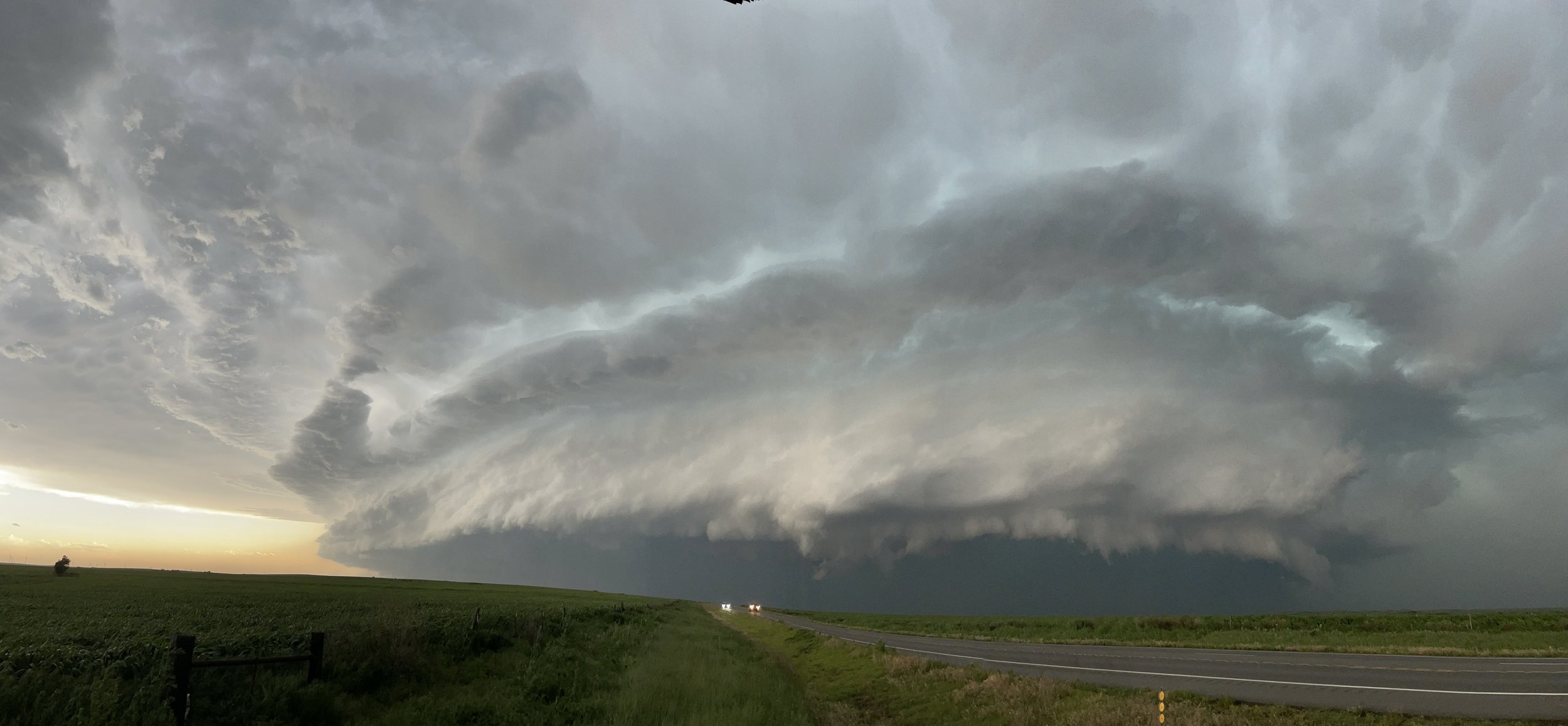
Large supercell near Fort Supply, Oklahoma
Target: Harrisonville, Missouri
This local chase started when a supercell exploded over the Kansas City metro area. The environment was supportive of further strengthening under northwest flow aloft, so as the storm matured and drifted south, I led it south on HWY 291 to Harrisonville. At that point it was clear it was going to drift further southeast, so I took HWY 2 east out of Harrisonville to East Lynne, then briefly took Road K north toward the town of East Lynne. After discovering I was too far north and east, I came back to HWY 2 and drifted a touch to the west toward Harrisonville. About halfway between East Lynne and Harrisonville, I encountered 1-2 inch hail, so not wanting to lose any glass I stopped to let the storm pass my location. Once the hail and rain started letting up, I took HWY 2 further west toward Harrisonville, encountering 2-3 inch hail on the ground. As I got back into the southeast side of Harrisonville on HWY 2 I stopped at a church, where an adjacent, large grass field had 3-4 inch hail. After measuring a few stones, I continued behind the storm to the south along I-49 to Adrian, where I took HWY 18 east to reconnect with the storm. Once it passed south of my road, there was no more keeping up with the storm, so I called the chase and headed home.

3.7 inch hail found in a field along HWY 2 near Harrisonville