

Chase 2016
Target: Dalhart, Texas
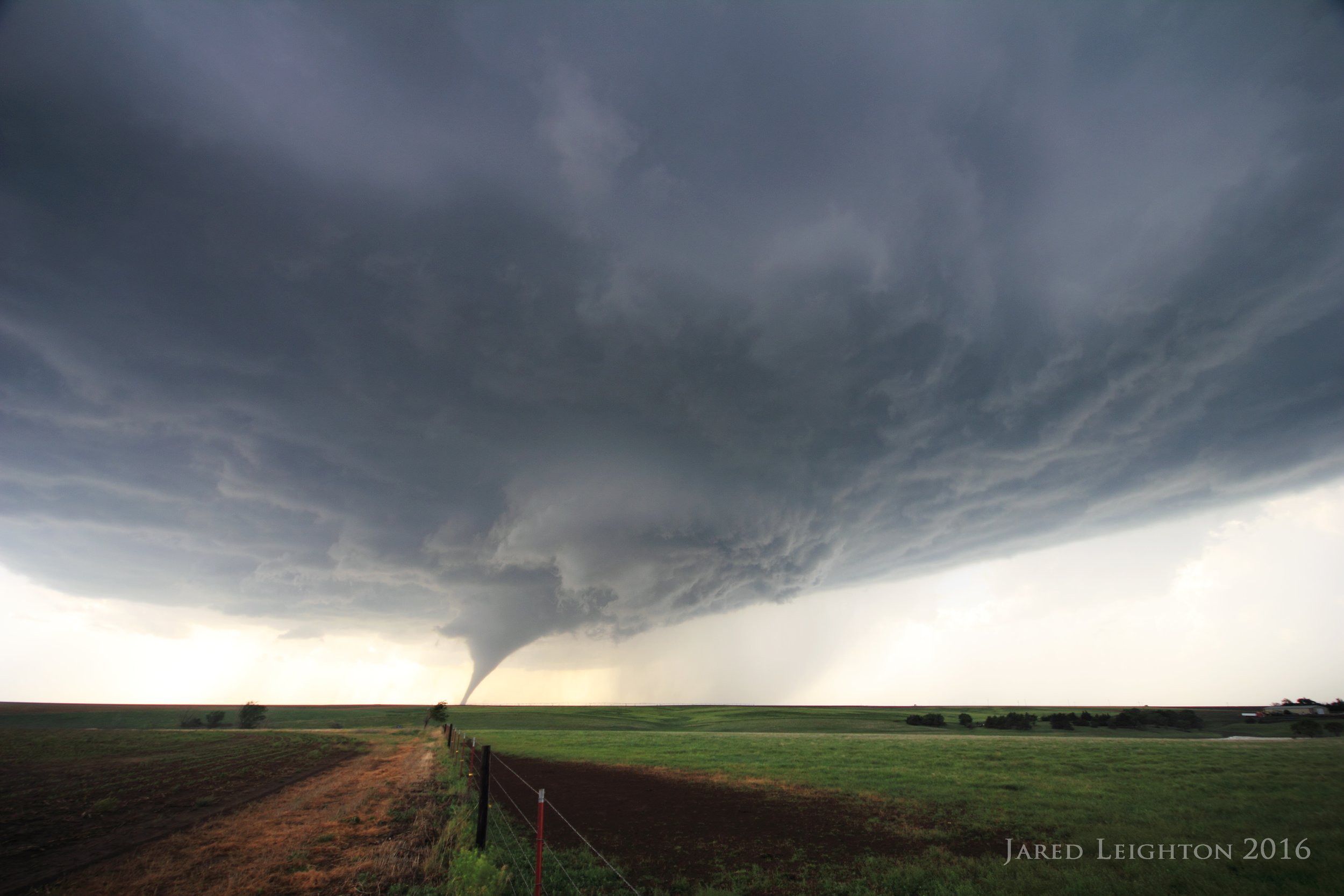
Departed Kansas City around 7 am, intending to get to the Texas Panhandle by 3 pm. Despite the forecast parameters being maximized that evening in the northern Panhandle up to Lamar, Colorado I opted for the quicker southern route through Joplin-Tulsa-OKC on I-40/44 into Amarillo. Upon my arrival to Amarillo storms were ongoing just west of Amarillo. Convection at this point was still immature, so I took Highway 287 north out of Amarillo, opting for a strategy of getting north of the convection and being able to move south along the line to the best storm, as opposed to trying to chase storms north. Since storm motion was north/northeast I took Highway 354 west in Channing, where I stopped for a few moments to watch the developing supercell. At this time there were about 3 separate updrafts along the line, so until they merged into one dominant updraft convection would remain marginal. So, I took the opportunity to get ahead of the storms, taking Highway 385 north into Hartley, Texas. As the storm moved over Dalhart, Texas it finally shook off all the mergers and began its rapid strengthening. I bypassed Dalhart to the east and picked up Highway 54 between Dalhart and Stratford, Texas. After getting to Stratford, I took Highway 15 east out of Stratford. When I got about 5 miles east of Stratford I pulled over into a field and beheld the incredible supercll that was currently near/over Stratford. Inflow winds at this location ranged between 40 and 50 mph, with large dust clouds being kicked up everywhere. Absent any gravel roads stair-stepping northeast across the Beaver River in the Oklahoma panhandle. I opted to follow Highway 54 northeast into Texhoma, Oklahoma, then come back to the storm, which was still on a north/northeast trajectory across the Panhandle. Upon arriving to Texhoma, I took a country road back to the west to get closer to the storm, but again, absent any passable roads across the river I opted to stay close to Highway 95. Just north of Texhoma on Highway 95 I pulled over to take a look at the storm and off in the distance, about 8-10 miles from my location the storm produced its first tornado, a brief elephant truck that lasted 1 to 2 minutes. While still at that location the storm produced a second tornado that lasted 3 to 4 minutes. As dusk settled in, and upon taking an eastward turn on Highway 412 toward Guymon, Oklahoma I stopped for one more look at the storm. It produced one more low contrast tornado just southeast of Elkhart, Kansas. I preceeded the storm into Guymon, but by this time darkness had settled in and I finished the chase in Guymon.

Supercell near Stratford, Texas
Target: Jewell, Kansas
In a day that was anticipated to be rather active, Josh Boustead and I met near Jewell, Kansas and watched storms near Superior, Nebraska. The only real interesting part of this event was the incredible motion underneath the updraft of a stationary marginal supercell near Superior. As the sun set I dropped south out of Superior toward Jewell. Flash flooding prevented any further chasing, so I called the chase early and went back to Kansas City.

Marginal Supercell near Superior, Nebraska
Target: Garden City, Kansas
Started the day in Kansas City, as this was the first day of a prolonged storm chase trip. Left KC around 930 am, with the goal to get to Garden City, Kansas. As I got to Garden City Josh Boustead and I noticed that the better cumulus field was a bit north of Garden City, just west of Scott City. We sat in Scott City for a while and ultimately adjusted west about 10-15 miles. We followed a strong storm north of our location to a rural field just to the northwest of Leoti. It formed a couple brief tornadoes, but the highlight of this storm was its nearly stationary movement, which allowed us to sit in one spot for about 2 hours watching the beautiful sculpted supercell. We finished the night just northwest of Leoti and drove to Garden City for the night.

Supercell near Leoti, KS
Target: Dumas, Texas
Left Garden City and headed south toward Perryton, Texas then eventually Dumas, Texas. Waited for storms to form in the Texas Panhandle until about 5 pm. An interesting, but not overly strong storm formed just to our north and moved toward Texhoma. Following that storm northeast toward teh Oklahoma Panhandle it was apparent that it wasn't going to survive. So I decided to bust north back to Garden City where a couple severe storms had formed. While working my way through Liberal the storm near Garden City formed a large tornado just west of Garden City. It formed a couple tornadoes northwest of Garden City that night, but by the time I arrived to the storm it was rain-wrapped and dark, making any tornado intercept nearly impossible, especially considering the muddy roads. Dropped south out of the storm along Highway 83 and salvaged the night shooting some night time structure then ended in Garden City.

Supercell north of Garden City, Kansas
Target: Shamrock, Texas
In probably the most frustrating chase of my trip, I started the day in Garden City, Kansas with the intent to get to Laverne, Oklahoma or Canadian, Texas for Texas Panhandle convection around 3 pm. As I was heading south a strong storm formed just south of Shamrock, Texas and quickly became supercellular. So, I made haste for Shamrock and dropped south toward Quail. Upon reaching the storm it looked like it was skinny and starved. It looked like it wasn't going to survive long, so I went north with Josh Boustead and Scott Nicholson toward Canadian. My reason for going north was to get in position for the next day in Kansas/Colorado/Nebraska. However, shortly after I went through Wheeler, Texas another severe storm formed just south of McLean, Texas. This storm looked beefier than the earlier storm, so I turned around and went for that storm. Right as I turned around a few storms formed near Canadian, Texas and Woodward, Oklahoma. Since I was closer to an already formed storm I decided to stick with the McLean storm. After a few indecisive moments I got into the hail core and watched the updraft die on Interstate 40. I ended the day frustrated in Liberal, Kansas.

Distant supercell south of Pampa, Texas
Target: Dodge City, Kansas
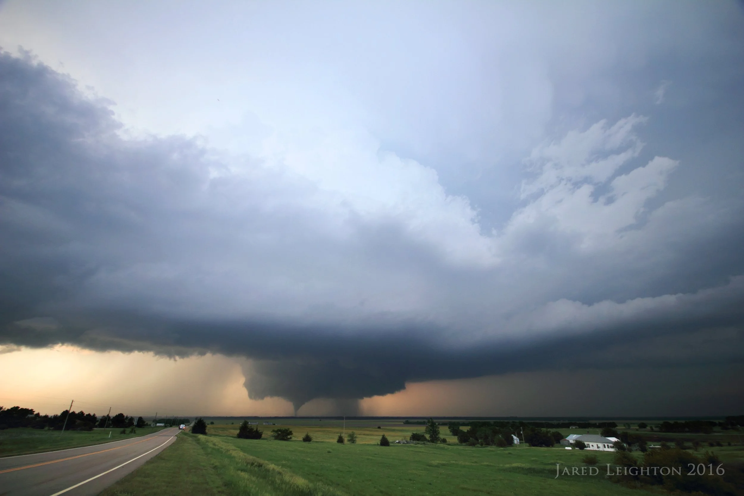
After a couple frustrating days of chasing my tail and being indecisive I resolved to make a forecast and be patient with my target. With a strong dryline bulge forecast to nose into Dodge City and with decent low and mid level flow I resolved that I would wait in the Dodge City area until convective initiation. Overnight convection pushed an outflow boundary down to the Kansas/Oklahoma border, so my original step was to go from Liberal out to Meade, Kansas and see how the surface conditions fared through the day. Ultimately the boundary pushed a little north and set up around Dodge City. So I moved up to Cimarron, Kansas and waited for about 2 hours for storms to go up. An early tornadic storm went up near Scott City, and while it was tempting to go after, being only an hour away, I resolved earlier to be patient. So, I waited for my target to light up. Finally, after several hours of waiting a strong storm went up north of Minneola. So I dropped south out of Dodge City and intercepted the storm between Minneola and Dodge City. Quickly it formed a lowering and a funnel. This funnel might have been tornado 1, but it was unclear if the rope funnel actually had a ground circulation. Shortly thereafter it formed a tornado just west-southwest of my location. The tornado grew into a well formed stovepipe with lots of debris. I followed the tornado along Highway 283 toward Dodge City. As it occluded, it formed a second tornado, which was formed simultaneously with the first tornado. As the first tornado went deeper into the rain the second tornado became well formed and continue to move toward Dodge City. That tornado occuluded just southwest of Dodge City, but unfortunately a third tornado formed just southwest of the town and moved northward through the far west side of Dodge City, barely missing the casino and events arena. Working through the center of town I could see the well formed tornado (3) moving through the far western part of Dodge City and move northward into open country once again. I took 110 Road north out of Dodge City and as I got about 3 to 5 miles north of town and as tornado 3 was roping out, I looked back toward Dodge City and saw tornado 4 forming just to my south, along my road, moving north. It caused a few power flashes a mile or two down the road from me. So after a few photos I pushed further north, and away from the approaching tornado. I noticed it cross my road toward the east and go into heavy rain. At that time I decided that there was too much rain to continue watching this tornadic storm, so I turned around and headed back south through the damage path back into Dodge City. I met back up with Josh Bousted, and we went after a few other storms east of our location. After striking out on further storms we called it a night and finished our crazy day in Pratt, Kansas.

Tornado between Minneola, Kansas and Dodge City, Kansas
Target: Salina, Kansas
Started the day in Pratt, Kansas with a leisurely breakfast. The forecast was for extreme instability to build into Kansas, but forcing was expected to be non-existent or modest, at best. There was enough of a signal in the models to at least keep us from going back to Kansas City for the evening. Instead we decided to wait the day out in Hutchinson, Kansas. While at lunch in Hutchinson, we continued to monitor the satellite trends to get an idea of where convective initiation would take place or if it would take place at all. Around 3 pm, two separate agitated cumulus fields were evident on satellite and a tornado watch was issued for eastern Kansas. As we left Hutchinson Josh Boustead and I made a decision to go after the cumulus to the northwest of our location. We took Highway 96 into Nickerson, then north toward Highway 56 east of Lyon. On our way north we noticed explosive convection almost directly ahead of us. We decided this storm near Bennington, Kansas would be our target. Even at the moment of convective initiation given the amount of available energy for the storm to work, the location near Bennington seemed prescient. Once we arrived to McPherson, and after a torcherous drive through the heart of McPherson, we took Interstate 135 north through Salina. We came into view of the base of the storm around the time we arrived to Salina and immediately noticed a funnel dipping down from the high base of the storm. Before our arrival to the storm it had already produced a funnel, and perhaps even a weak tornado. We then merged onto Interstate 70 eastbound and got off at Niles Road to watch the storm. This vantage point was elevated over the Kansas fields and offered a great view of the developing tornado. Around 7:09 pm, the tornado formed and quickly grew into a very strong to violent tornado. Once it got to our east and became rain wrapped we moved eastward along I-70 and got off on Solomon Road, about 5 miles to the east of where we saw the tornado form. As it passed to our north we saw that it was a wedge-shaped tornado, likely violent. Our next stop along the interstate was in Abilene, where the tornado narrowed and appeared to be weakening. As it passed east of our road it quickly morphed back into a wedge-shaped tornado and continued east-southeast toward Chapman. We then chose Highway 43 to drop south. Before going south into Enterprise we took a look at the tornado, and for the first time ever I heard the tornado "roar" which sounds like a waterfall or a jet engine. Finally we dropped south out of Enterprise and found one last north-south road to get a look at the rain-wrapped wedge tornado, as it went through the south side of Chapman. We could not see the tornado from our vantage point, due to the fact that it was wrapped in rain, but we did hear a deep rumble which sounded like a jet taking off...quite an impressive sensation. With light fading and the growing idea that the tornado would eventually weaken and likely not come out of the rain before the weakening we called the chase over and went to Salina for the night. When all was said and done the tornado lasted 90+ minutes with a 26 mile path length. Chapman was ultimately spared, however there were some residences on the south side of town that were destroyed. Perhaps even more interesting were the railroad tracks southwest of Chapman that were destroyed. The tornado was rated EF-4, due to the damage it caused to residences southwest of Chapman. To this date that was the strongest and largest tornado I've ever seen.
Early stages of the long-tracked EF-4 tornado that churned from Bennington, Kansas to Chapman, Kansas
Target: Sterling, Illinois
In what was anticipated to be a high impact day in northern Illinois I targeted an area ahead of where I anticipated the E/SE storms to initiate. Anticipated storm motion was around 40 mph, so getting behind any storm would likely end the day prematurely, so the strategy was to stay well ahead of any storm activity. Initial cells formed in eastern Iowa, near Davenport and quickly crossed the Mississippi River into the target area. Given the volatile atmosphere it was surprising that storms took so long to get organized. While the gradually gained strength they began interacting with each other, which under normal circumstances would be problematic. But, with the volatile atmosphere the storm interactions proved to not be a problem. I jumped on the lead cell near Amboy, Illinois as it demonstrated the most impressive visual characteristics. After following it into Sublette I cut it loose as it was getting filled in with rain. This cell however went on to produce at least one large tornado near Earlville. There were several supercells in the wake off the Sublette-Earlville storm, so I dropped a litle south toward Ohio, Illinois to catch the next cell in line. I intercepted this cell between Ohio and La Moille. The low level characteristics were fantastic and supposedly it produced a tornado here, but I missed it. I led it southeast toward Troy Grove, where it produced a second weak and brief tornado just west of Troy Grove. Noticing it getting late and given the proximity of I-80 I followed it back to the interstate where I would give it one last chance. Near Marseilles, despite the radar signatures indicating the best rotation north of the interstate I noticed that surface winds were strong originating from that location, indicating that the new updraft was across the interstate from me. So I pointed my camera south to see what it would resolve within the lightning. After a 17 second exposure a well defined tornado showed up. This tornado did some minor damage to the town of Marseilles and pehaps more significant damage to the town of Seneca a little later. 8 hours from home and approaching 10 pm, I decided to call it there and head home.

Early stages of the tornado that hit Seneca, Illinois. This was on I-80 near Marseilles, Illinois looking S/SE
Target: Lake Toronto, Kansas
A frustrating chase started out at home in Lee's Summit around 4 pm. An outflow boundary remained generally stationary across southeast Kansas all day, and convective models indicated storms would fire in that vicinity around sunset. Given ample instability and good shear I set out for Nevada, Missouri, which turned out to be too far east. A supercell formed near Matfield Green, Kansas and slowly moved south, producing at least two large tornadoes. Once the storm cut off my access to the west, I decided to call the chase off near Lake Toronto, considering the lack of any reasonable road options. The storm was putting down several CGs, so I decided to use the lake as a nice foreground for the lightning strikes.
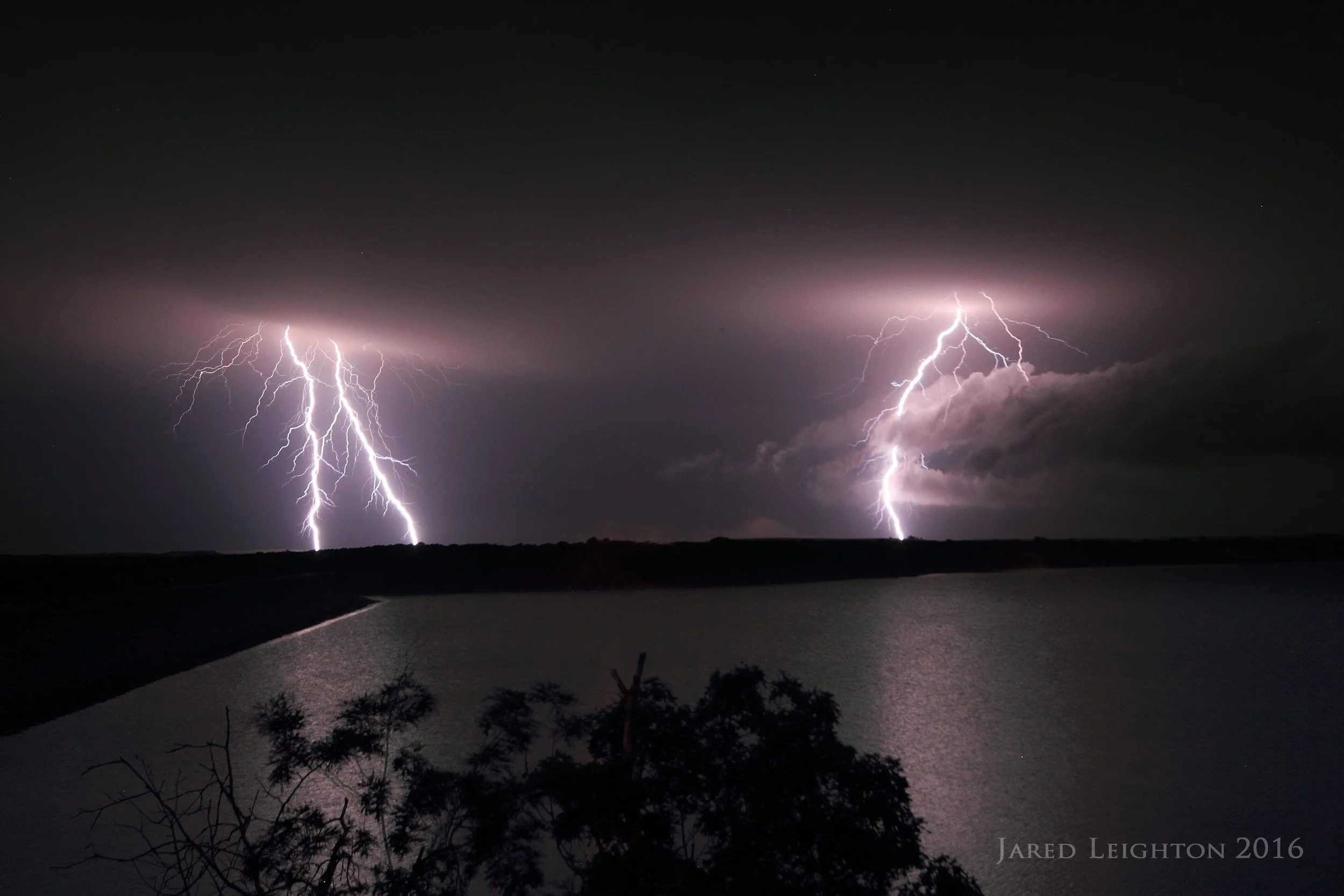
Lightning strikes across Lake Toronto, Kansas