

Chase 2014
Target: Manhattan, Kansas
I had been watching April 12 for a potential chase for several days leading up to that day. As more model runs came in, it appeared that the cap would prove to be too strong to allow any chaseable convection that afternon. So after spending the day routinely, I noticed some good cumulus formation in C Kansas, and after SPC issued a MD for potential development, I grabbed my gear and headed out toward central Kansas.
It appeared that the storm would move to the northeast away from my target, however after splitting, the right mover took a slow easterly movement toward Riley, Kansas. I got off of Interstate 70 onto Highway 177 N toward Manhattan, and after dealing with the traffic in Manhattan got on Highway 24 toward Riley.
I finally caught the storm just east of Riley, and took several structure shots. Since it was throwing several CG lightning bolts I decided to experiment with some daytime lightning photography. As the sun set, I moved closer to the storm and found a dormant/dead oak tree to use as a silhouttte foreground for twilight lightning shots. As darkness set in I went back toward Manhattan and caught the storm one more time as it passed over Tuttle Creek Lake. It was here that I seredipitously met up with Scott Currents for a brief time. At the lake I took several more nighttime, lightning-lit updraft shots over the lake. The storm set off a brush fire just south of the lake and lit up the updraft with an orange hue. I had aspirations of using the fire as photography fodder, but couldn't access it via any passable roads. At that time I decided to head home on Highway 24, paralelling the storm to see if it would become interesting again. It did not, and I finished the trip to Kansas City around 12:30 am.
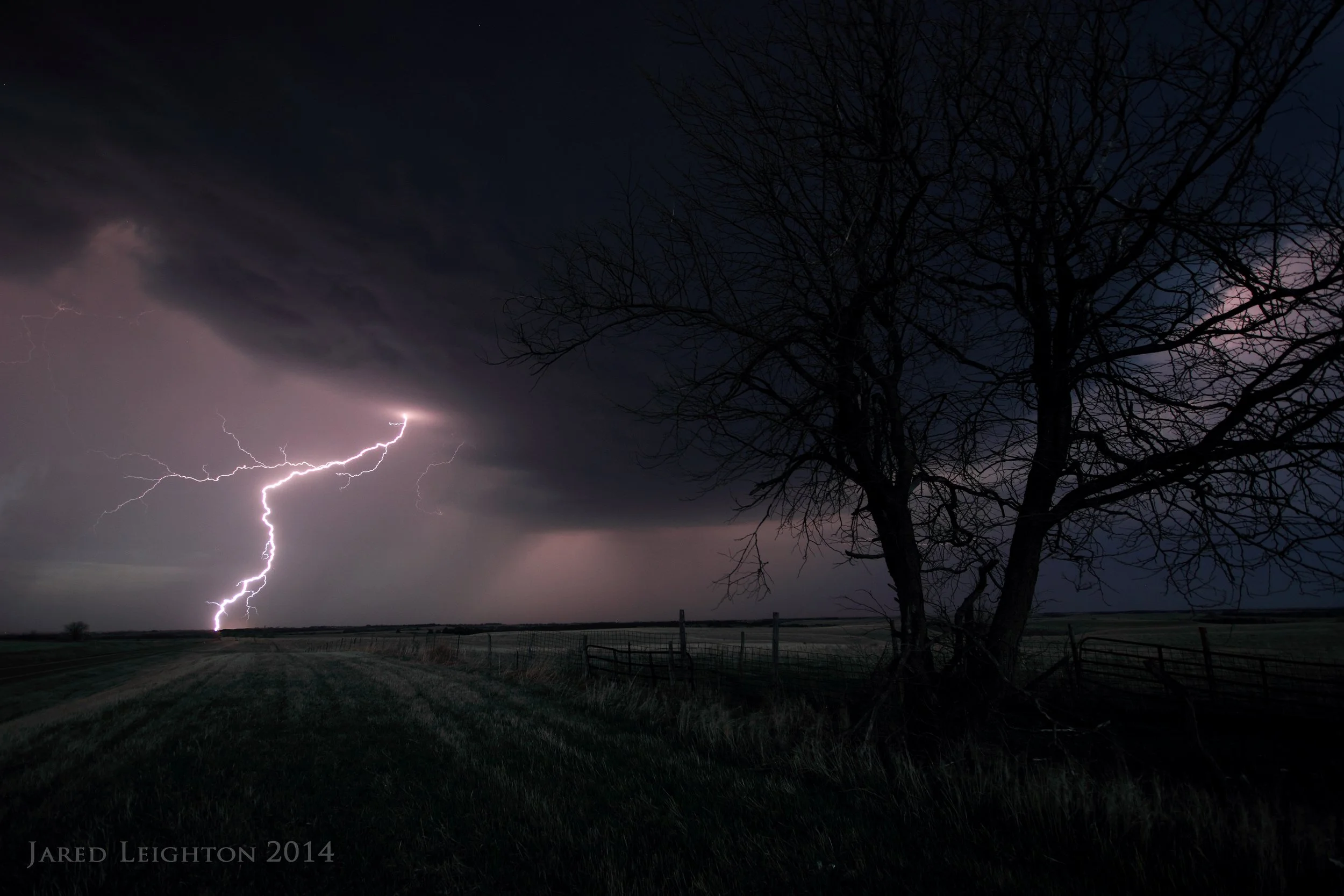
I found a dormant/dead oak tree to use as foreground for some twilight lightning shots.
Target: Shamrock, Texas
Left Kansas City around 7:30 am and met up with Bill Gargan in Topeka, KS for a trip to the southern High Plains. The set up was expected to be marginal from the beginning, but considering this day presented a rare chase opportunity to the early 2014 season we made the trip out to western Oklahoma.
As we approached Shamrock, TX deep convection initiated in the far eastern Texas panhandle. At Erick, OK we dropped south toward Hollis, OK but stopped short of Hollis as the high-based supercell became very organized. We repositioned to the east/southeast toward Mangum, OK and watched the storm go through several mergers as several weak mid-level updrafts went up to the southeast of the storm. Throughout the storm's lifespan it produced several scud formations that looked at first glance like tornadoes. This was a classic case of tornado-look-alike scud formations that could have and may have fooled many chasers/spotters into erroneously reporting tornadoes. Unfortunately due to the strong mid-level forcing and perhaps a weak cap the storm never successfully survived all of the mergers with other updrafts. Aside from the numerous weak storms in the area perpetual mid-level clouds precluded good viewing of the main storm's updraft, making photography of the storm very difficult. While the storm's inflow winds (35 mph) were very strong, indicating it had no intentions of weakening the terrible viewing and the seemingly uphill battle it was facing to fight off the other updrafts we opted to drop south to a cluster of supercells in far northern Texas.
As we drove south through Altus, OK we decided that we would not be able to reach the northern Texas storms in a reasonable amount of time, so we ended the chase in Altus.

High-based supercell near Wellington, Texas
Target: Imperial, Nebraska
I took the opportunity to go after a more non-conventional, secondary target in SW Nebraska. The obvious target was in southern Oklahoma and northern Texas. Considering both targets would be about the same distance from home, I decided to play the area where chaser convergence would be minimal. Also considering the somewhat unique set up I felt that the chances for tornadoes was a bit higher in the high plains of Nebraska.
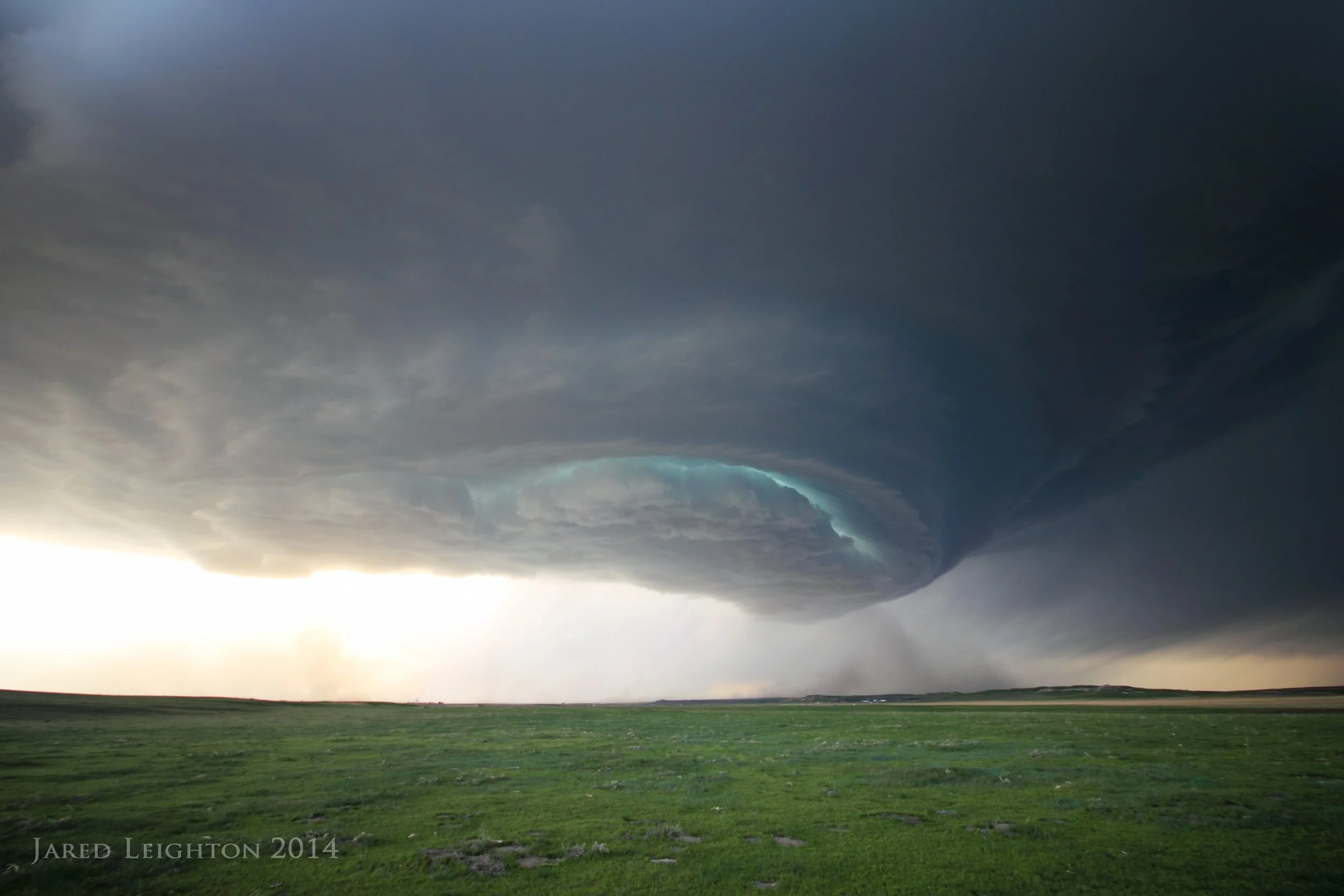
The forecast was unconventional in that storms were expected to be surface based north of a warm front where winds were out of the northeast. The wind orientation aided in strong low and mid level shear, virtually guaranteeing picturesque supercells and perhaps tornadoes. While the tornado forecast didn't pan out, the High Plains delivered with extreme beauty as a supercell formed near McCook, Nebraska and moved northeast toward Lexington, Nebraska through the evening hours.
The days started in North Platte, Nebraska as convection fired up in north central Colorado. With that convection being too far to try to reach we held our target of Imperial, with hopes that the convection across northeast Colorado would eventually get going. About 5:00 pm storms fired up just southeast of Imperial, Nebraska, so we dropped southwest out of North Platte to intercept. Due to the extreme forcing too many storms fired and no single updraft took over as the dominant storm, so it became a convective complex over Wallace, Nebraska.
Recognizing that the storms near Imperial weren't going to be chaseable we dropped south even farther to a storm coming out of northern Kansas toward McCook. In true fashion the storm dissipated as it moved north toward our location near Trenton, Nebraska. Putting all of our eggs in this storm's basket, we moved toward McCook to see if it would refire. Miraculously it did refire and became a picturesque supercell. Due to the fast northwest motion (24035kt) we never got out of its southwest flank. The storm became tornado warned as it moved through Lexington, Nebraka, but shortly thereafter it went elevated, causing its motion to become too fast for us to keep up with. We called off the chase south of Loup City, Nebraska and headed for home.

Beautiful Supercell in rural Nebraska, southwest of Lexington, Nebraska
Target: Lincoln, Nebraska
Woke up from a midnight shift around noon, and quickly got ready for a chase in SE Nebraska. The target on this day was fairly well defined, which makes some challenges in storm chasing less challenging (like picking a target or forecasting the evolution of a storm) and makes some challenges even more challenging (like dealing with hundreds or thousands of other chasers that found the target equally as easy to find). The target was SC Nebraska where a surface boundary triple points set up. Overnight convection laid down an outflow boundary which when combined with a northward moving warm front caused a very tight moisture and thermal gradient across SE Nebraska.
Due to leaving a tad late we were only able to get slightly west of Lincoln, Nebraska when the storm formed and started to move east along the boundary. This caused us to miss the first few tornadoes of the day. Unfortunately these were the most visible tornadoes. We dropped south from I-80 at Hwy 462, about 10 miles NE of the storm. We waited there for the storm and ongoing to tornado to reach us. Upon its arrival we noticed that the storm's base was incredibly low and it appeared that it was transitioning into more of a HP mode, further limiting our visibility. From there we dropped further south to get out of the path of the tornado, and went west to Hwy 420. At this point the storm's southern flank caught us and perhaps a quarter to half mile way in the field we could see a very large rotating mass just to our NW. We then left that intersection and dropped south to Friend, Nebraska, along the way encountering incredible RFD, which slammed mud/field debris against the side of the car.
At this point we decided to no longer try to mess around with the updraft region of the storm and went northeast back to the interstate to get way out in front of the storm. We got to Lincoln and went a mile or two north on NW 48th street in western Lincoln. After grabbing a few distant HP supercell shots and witnessing an RFD occlusion we moved to the NE along I-80 another 5 miles and got off at Hwy 77 in north Lincoln. Here we let the storm evolve one more visibile updraft/occlusion (which may have tornadoed). The storm developed an incredible shelf cloud, which nearly overtook us before we jumped back on the Interstate. At this point we decided that the storm was no longer photogenic and ended the day in Omaha, Nebraska.

A shelf cloud races east along the southern flank of the storm, just north of Lincoln, Nebraska
Target: Scottsbluff, Nebraska
In the first day of what is planned to be a string of several consecutive days of High Plains chases May 19 was expected to be more of a travel day to get to the target area for the next few days. Storms were expected, however expectations of how photogenic they would be were rather low.
Storms initially fired up in far eastern Wyoming during the afternoon hours, but due to meager instability at the time, as well as perhaps some capping issues the storms never really got too interesting. By 5:30 pm a couple very high-based marginal supercells formed in eastern Wyoming and moved eastward toward Harrisburg, Nebraska. The two high based laminar clouds greatly resembled UFOs as they moved east/southeast toward Bridgeport, Nebraska. About that time a more robust supercell formed just east of Cheyenne, Wyoming and started drifting southeast toward Kimball, Nebraska. Took HWY 71 south from Harrisburg to Kimball as the storm grew in strength and became more organized. The fast movement of the storm required me to use Interstate 80 to stay in front of it, which wasn't very much of an inconvenience since the updraft paralleled the interstate. The best structure was noted as the storm paralleled I-80 between Sidney, Nebraska and Chapell, Nebraska. Given the onset of darkness, the storm's fast forward progress, and an expected weakening with time, the chease ended in Chapell, Nebraska with half dollar sized hail and 50 to 60 mph winds.
High-based supercell along Interstate 80 between Kimball and Sidney, Nebraska
Target: Scottsbluff, Nebraska
Started the day in Sidney, Nebraska as this was day 2 of a multi-day High Plains chasing trip. The first storms went up fairly early, around 2:00 pm just west of Chugwater, Wyoming. I took the short trip through Scottsbluff, Nebraska, ultimately coming into view of the storm near Veteran, Wyoming. To the west of the storm, another supercell fired up and paralleled the track of the lead supercell, just to its southwest. This orientation of the storms, as well as high rain-free bases allowed viewing of both storms simultaneously. While the bases were visible, ample low clouds precluded any updraft viewing. The western storm demonstrated a flat, laminar base, which showed no good signs of rotation. The western storm appeared to contain more traditional, classic supercell base structure, with a slowly rotating lowering and a long inflow tail. While the western storm indicated the best signs of organized supercellular behavior the cold temperatures and dry air precluded any tornadic activity. Followed the storms back to the east/southeast through Yoder, Wyoming and Lyman, Nebraska, ultimately driving through the bluffs at Scottsbluff. It was about this time that it became apparent that the storms were likely done. I stopped at Chimney Rock, just outside of Scottsbluff to take some photography with the storm in the background of the frontier landmark. The day ended back in Sidney, with hopefully another day of High Plains chasing on May 21.

Base of a maturing supercell near Veteran, Wyoming
Target: Fort Morgan, Colorado
This was day 3 of a 3-day trip to the High Plains. The day started in Sidney, Nebraska, with the target of Ft. Morgan, Colorado. Short range, hi-res models indicated that there would be a lone supercell forming over the Denver Metro area, moving east toward the High Plains of eastern Colorado through the afternoon hours.
Dropped southward out of Brush, Colorado toward Aurora, and eventually set up about 15 miles east of the supercell just east of Denver International airport. Due to the wide expanse of the airport, I could not continue west toward the city to intecept the storm. Instead I waited on the eastern edge of DIA and watched from a distance. While it moved closer to my position it produced a brief tornado just S/SE of DIA. Once the updraft crossed my N/S road, I moved east with the storm, occasionally dropping south into the notch to try to get a look at the developing storm. These attempts to see much failed, as the storm transitioned into an HP mess, that precluded even notch-dwellers from seeing much action. Eventually I dropped all the way south to Interstate 70 east of Aurora and followed the storm along the Interstate.
At Byers, Colorado I exited the Interstate and used Highway 36 to stay with the storm. Near Byers, the storm chaser convergence became too much for my comfort level. The lone supercell moving through an area with an extremely low density of usable roads caused about 2500 chasers and researchers to converge along Highway 36. Given the non-photogenic nature of the HP storm and the number of chasers present, I decided to call the chase off early and start the long drive home.

Supercell moves eastward out of Denver, passing just south of Denver International Airport
Target: Sidney, Nebraska
Left Kansas City around 7:00 am, and picked up Josh Boustead in Omaha around 10:30. From there we pressed westward on I-80 to get to Sidney before initiation of storms off the Cheyenne Ridge. Storms never really materialized in our area, as some low/mid level warming prevented strong enough lapse rates to allow for robust convection. Instead we took the chance to collect a few photos of the beautiful western Nebraska landscape.

Thunderstorms forming over western Nebraska, near Sidney
Target: Grand Island, Nebraska
Left Kansas City around 11 am with the intent of getting to Grand Island, Nebraska and watch storms in south central Nebraska. The storms throughout the day were generally pretty strong, but due to lack of any appreciable wind shear the updrafts were not able to reside longer than 30-40 minutes. After watching several storms die between Grand Island and St. Paul another storm gathered some strength and rotation west of Grand Island. We drove south, through the core and emerged under the updraft in Grand Island. Using the Platte River as a foreground I took a few shots of the rotating updraft. After about 30 minutes the storm ultimately died east of Grand Island. On our way to Omaha to end our night, another storm started rotating near Waverly. Found a neat corn field to shoot night time supercell pics just north of Waverly, Nebraska. Once that storm lost its visible structure we finished the trip by going through its core in Gretna, Nebraska. There we encountered heavy rain and golf ball sized hail.

Supercell with mammatus near Grand Island, Nebraska
Target Oakley, Kansas
Left Kansas City early and picked up John Mark Zini with the intent of getting to the Wakeeney/Oakley area. The forecast as for two potential targets. One target was located north/northeast of a surface low pressure where winds were backed to the E/SE. A second potential target loomed along the dryline across far SW Kansas, southward to the Texas panhandle. The tornado threat was minimal for the southern target, but better instability and deep layer shear made that target tempting for big storms to form. The northern target was more tempting for tornadoes. Favoring the northern target, we held our ground in Oakley, waiting to see how the situation would unfold.
Storms began in far eastern Colorado and moved east/northeast into the better tornadic environment. Immediately multiple updrafts turned the scenario into a multicell situation, however one dominant updraft nearly vanquished all of the competing updrafts. Unfortunately enough of a cold pool developed among all of the storm activity that strong outflow surged away from the storms, virtually ending any chance of these storms from surviving.
The lone remaining option was to drop south and play the secondary/southern target in SW Kansas. As we dropped south into Scott City another multicell system formed near Tribune, Kansas. We intercepted the weakly rotating storms near Leoti, Kansas and were able to capture a few images of the complex. Finished the day near Lake Scott for some unsuccessful lightning photography. The day became more adventurous when we blew a tire on the way home. The delay resulted in us sitting in a ditch until midnight and having to find a motel room in Hays.

Lightning from a weakly rotating storm near Leoti, Kansas