

Chase 2013
Target: La Crosse, Kansas
Left Lawrence, Kansas around 9:15 am and met up with Scott Blair in Ottawa, Kansas around 10:00 am with the intent to get to Greensburg to catch a cluster of supposed supercells that short range convective models were hinting at occurring in southwest Kansas later in the day. After sitting in Greensburg for a bit, we adjusted north since it seemed as though updraft towers were doing a little better north of our location. Once we got to Rush Center one of the towers took off and morphed into a moderate supercell just west of La Crosse, Kansas. We intercepted the core of the storm near La Crosse and got into golf ball to tennis ball sized hail. We emerged from the core just east of La Crosse and followed Highway 96 through Albert keeping up with the southern flank of the storm. It looked as though it tried to get some low-level organization a couple times, but the highlight of the storm was definitely its mid level structure. Eventually the storm picked up its pace and got in front of us, and we had to cut the storm loose just east of Great Bend

Moderate to strong supercell near Albert, Kansas
Target: Frederick, Oklahoma
Scott Blair and I left Ottawa, KS around 9:30 am, intending to head south (intentionally vague). We stopped in El Dorado, KS for about an hour to ponder the SE Kansas/SW Missouri area since we were nearby and that area seemed to demonstrate a similar environment as the SW Ok area. Ultimately we opted for the higher probability target at the triple point in SW Oklahoma. Before reaching OKC we noticed a strong cell on radar near I-40 moving nearly parallel to the well defined SFC thermal boundary and decided to try our luck with this storm, suspecting we'd have the SW Ok play as a Plan B. Well we needed that Plan B as the storm crossed the boundary and died quickly. We then targeted the SW Ok storm and intercepted it in Lawton, Oklahoma. We found an elevated plane at a bank in town and watched the storm approach the city from the west.
As we watched the rapid low level rotation in the lower levels of the storm we noticed what looked like a very poorly contrasted bowl-shaped lowering tucked into the precipitation, and within minutes of watching that feature we saw two or three very distinct power flashes 4-5 miles W-SW of Lawton around 5:25 PM CDT.
Anyway, even after the power flashes we weren't confident enough to make conclusions or reports about it being a tornado, although we still strongly suspect the lowering was a funnel and that the circulation did briefly reach the surface. After that, we simply paralleled the updraft of the lead storm back to Chickasha before calling it quits. A few times along its path from Lawton to Chickasha the lead supercell became organized enough to let us suspect it would tornado, but it never really got it all together. Overall the contrast and features were poorly defined through the day. That and lack of light precluded me from getting any usable photos of the storms.
VIEW GALLERY

RFD wrapping around the low level mesocyclone, with brief tornadic circulation that caused three power flashes in Lawton, Oklahoma
Target: Hoxie, Kansas
Left Lawrence, Kansas with Scott Blair and Jenni Laflin around 12:00 pm with the intent to get to Oakley, Kansas for afternoon supercells. Along the way we noticed some towers going up north of Interstate 70, and decided to run north on Highway 23 toward Hoxie, Kansas. For the first hour or so the storm was disorganized, and produced little in the way of aesthetic pleasure. So, we managed to sample some marginal hail with the storm, and almost getting stuck on a muddy road before pushing southeast toward Wakeeney. Between Hoxie and Wakeeney the low level shear must have jumped quite a bit because within 5 minutes the cell went from mushy and disorganized to displaying an impressive, well-defined supercell structure, some of the best structure I've seen to date. Although the cell demonstrated phenomenal visual structure, curiously the radar representation was less than impressive as the storm seemed less like a supercell and more like an embedded shower within widespread light rain echoes. And although there were discreet, robust supercells only 40-50 miles to our south we opted to stay on our storm as we seemed to be the only chasers on the Hoxie to Wakeeney cell. As it started to lose its structure around sunset we jumped on the last cell of the day back toward Collyer, Kansas. After sampling a little post-sunset hail on the trailing cell we finished the day in Hays.
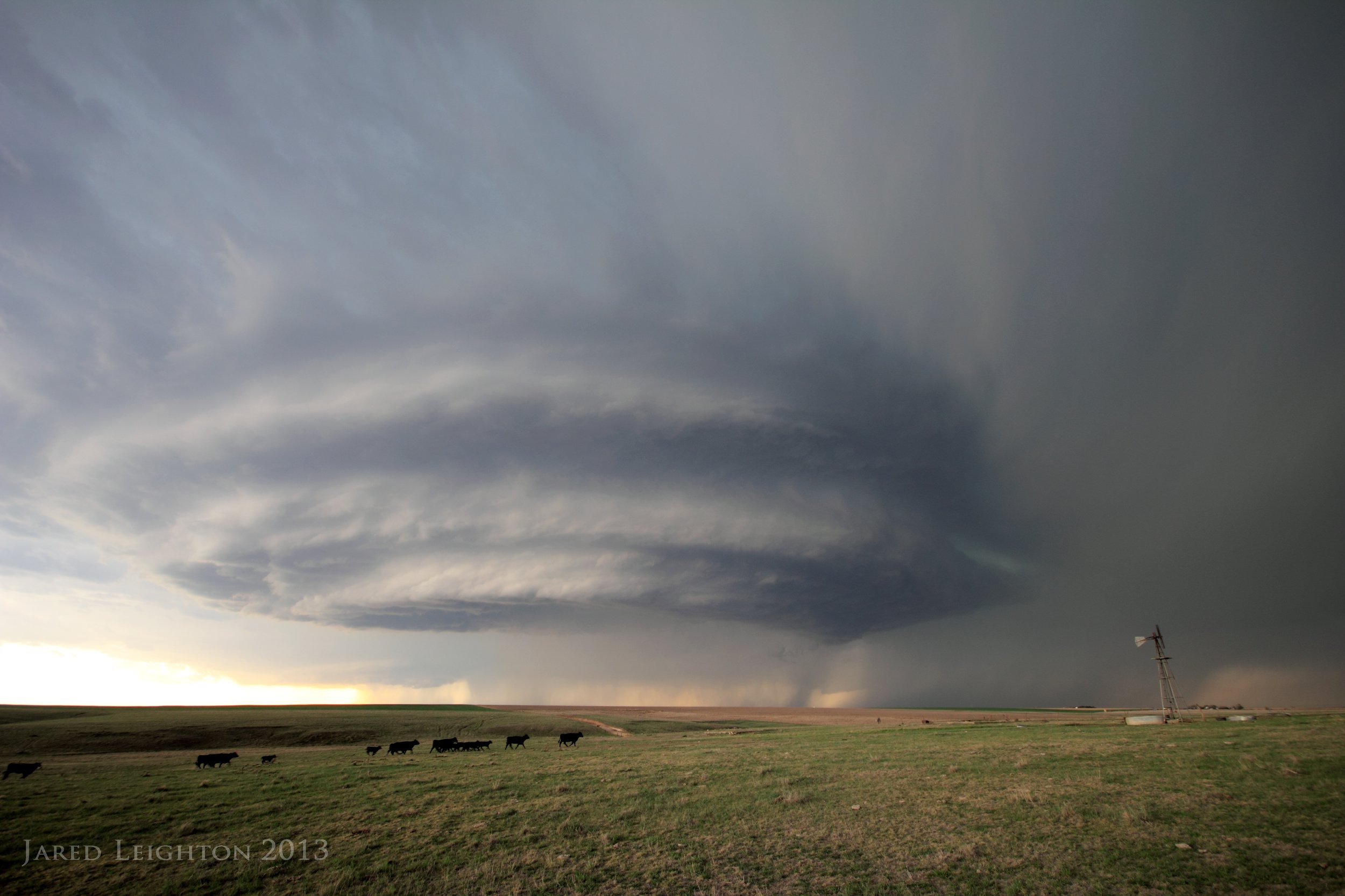
Well-defined supercell between Hoxie, Kansas and Wakeeney, Kansas, with cows in the foreground

Impressive supercell between Hoxie, Kansas and Wakeeney, Kansas
Target: Woodward, Oklahoma
Scott Blair, Jenni Laflin, and I departed Hays, Kansas around 10 am, with the intention to get to northwest Oklahoma before convective initiation around 3 pm. Upon arriving to Woodward, Oklahoma we encountered a high-based, low-precipitation cell. After a few photos of that skinny updraft we abandoned it for a more robust cell to the south, near Cheyenne, Oklahoma. We arrived to the cell near Seiling, Oklahoma and sampled its hail. Due to the storm's unpicturesque appearance we used the opportunity to sample the hail, getting 2-3 inch hail, with some isolated larger stones. We eventually called the chase off near Fairview in a field of canola plants with the supercell to our west.

Supercell near Fairview, Oklahoma with a field of canola in the foreground
Target: Greensburg, Kansas
This day will likely live on with me as one of the most painful chase experiences. I've picked the wrong storm plenty of times, and I've certainly made plenty of bad decisions while chasing. The consequences of both of those occurrences on May 18, 2013 will likely remain with me for a while.
The day started out with promise as the forecast was for a group of discreet supercells to form in southwest or west central Kansas later that day. I was on midnight shifts at the time, so I knew I had to stay close to home and that I had to chase the earliest convection. These decision points would factor into the pain that ensued that day.
I left Lawrence, KS around noon that day aiming at getting to Greensburg, KS by 4 pm and getting on whatever convection was available. Upon arriving to Greensburg a few updraft towers were going up along the dryline in west central Kansas. One cell quickly grew into a supercell near LaCrosse, KS. With the convection in the area looking high based and weak we opted to travel up Hwy 187 north to the cell moving NE toward I-70. During the trip the cell near the interstate went supercellular and took on characteristics similar to the LaCrosse supercell that remained nearly stationary for several hours and produced several large tornadoes the previous May 25. I was convinced this storm would do the same. However, upon arriving to the storm it became outflow dominant and weakened. The smart move would have been to drop south to the storm back near LaCrosse, but due to my time considerations I opted to gamble on the storm near the Interstate. By the time I followed the outflow dominant storm back to Hays reports of a large and vicious tornado started coming in on the storm just to my south. The middle of three supercells produced several tornadoes, at least one of which was rated EF-4, near Rozel, KS...merely 40 miles to my south. Dejected, I hopped on the interstate at Russell, and made the trip home to Topeka to report to my midnight shift an hour early.
Target: Wichita, Kansas
This chase was day 2 of a series of 3 consecutive chases that resulted in a lot of frustration. Similarly to the previous day the day started after waking up from a midnight shift. Left Lawrence, KS around 12:30 with a target of Wichita, KS. About the time we reached Emporia a supercell quickly grew to a mature phase and began producing very large tornadoes just southwest of the city. Since we decided we did not want to deal with the Wichita metro area, we set up on the far northeast part of town and waited for the cell to get through the city. Fortunately for the city of Wichita it quit producing tornadoes after the first couple on the southwest side of town. It quickly grew into a strong bow echo which raced northeast along the Kansas turnpike about 60-65 mph. We stayed in front of the bow wondering if it would be able to produce a tornado, but let it pass us in Emporia. The bow did produce a tornado, which several people witnessed, near Emporia. We battled our way back through the rapidly advancing bow back to Topeka and eventually to Lawrence, where we ended the chase. After having dinner on Massachusetts Street we exited the restaurant to find that in the wake of the storm the sky was putting on an incredible mammatus display. After a few shots of the mammatus, we called it a day and went home. This day is one of several that can serve as a reminder that you don't always need good storms to salvage something out of a chase.

Mammatus over Lawrence, Kansas
Target: South Central Oklahoma
Day 3 of a 3-day frustration-fest. Since this chase occurred on a long weekend for everyone, Scott Blair, Kris Sanders, and I left Lawrence, KS around 9 am with the intent to get to Oklahoma City by 2 pm for early initiation in South Central Oklahoma. Since the previous day yielded violent tornadoes south of where we were situated our strategy was to follow the pearl of supercell southward until we could reach the end of the line. The first storms went up around 2 pm, as expected, near Oklahoma City. We stopped in Newcastle, Oklahoma as a monstrous updraft went up just to our west. We figured it had potential, but due to the fact that the motion would take it into the OKC metro we opted for the cells to the south in more rural areas. This cell would become the cell that parented the Moore Tornado that was rated EF-5.
We latched onto another cell around Waurika Lake near Duncan, Oklahoma. We were too far east to be able to see the updraft clearly, but as it came into view we saw a few dancing streaks on the other side of the lake, about 10 miles away. The source of these dancing streaks eluded us, as we simply wrote them off as rain streaks, however a few reports of a tornado came in about the same time, so perhaps we saw the dissipation of a tornado as the updraft came into view. After watching that storm for a while we opted to continue south as the chain was filling in. Ultimately we opted to play the biggest storm of the day (aside from the Moore storm) near the Red River. We dropped south to Nocona, Tx to watch a monstrous HP supercell. As the storm began getting its act together a quickly moving left-mover came in from the south and disrupted the storm enough to end its life.
We then started north on Interstate 35, while just beginning to hear about the devastation the Moore Tornado left behind. On the trip north we stopped near Ardmore, Ok as the departing storms left behind a great sunset lit mammatus and rainbow show. We stopped in Norman for dinner, which was just long enough for city workers to open Interstate 35 back up to motorists. We crossed the path of the tornado as we went through Moore, and as expected it was certainly one of the most devastating sights I'd ever seen.

This supercell produced a tornado near Duncan, Oklahoma, on the west side of Waurika Lake
Target: Russell, Kansas
Left work around 4:00 pm and headed west on I-70 toward Salina, expecting storms to initiate around Lacrosse or Hays before moving northeastward toward Russell. Before getting to Russell I noticed a strong supercell near Smith Center, so I took Highway 14 north toward Beloit and Smith Center, intending to get to that storm. Figuring it would likely weaken upon my arrival I opted to play with the storms closer to the interstate. They never really got their act together, but they did produce some pretty structure and scenery. Josh Boustead, Barb Boustead, and I met up near the storm, and decided to drop south to a storm near Ellsworth, but upon arriving to that storm it promptly weakened, so we ended the day in Salina.

Weak, but picturesque supercell near Hunter, Kansas
Target: Coffeyville, Kansas
Due to work obligations I was unable to partake in the chaser convergence disaster near the Oklahoma City metro area this day. I was able to depart work around 4 pm and left Lawrence around 4:30 with an initial target of Coffeyville, Kansas. We dropped just south of Coffeyville on Highway 169 before heading west to intercept our first supercell. We ended up having to abort our intercept as we ran out of road options that would safely get us south of the updraft. Ultimately we watched the storm cross Highway 169 near Lenapah, Oklahoma. We then tried to follow it eastward on Highway 10, but it looked pretty ragged, and with it running away from the highway, we opted to head west to the next storm in line. We intercepted this storm west of Talala, Oklahoma, and while it was definitely a formidable storm it lacked the desirable sharp formation that one would look for in a strong storm. We decided to usher it back to Highway 169 before heading north. While watching it along Highway 169 I determined that the storm would likely not produce anything dangerous, so we went north into the precipitation. We stopped at Highway 166 and 300 Road, near Watova to look over some road options and noticed about 2 miles to our northwest a well developed cone tornado moving east toward our location. We watched it cross the road about a mile north of our location and form into a strong stovepipe tornado near Oologah Lake. After it left our vision we opted to end the chase and head toward home.

Tornado about to cross Highway 169 near Watova, Oklahoma
Target: Liberal, Kansas
This day marked my arrival to the HailSTONE 2013 operations after having to sit out the first few days of the project. We targeted the first storm just north of Liberal, and got some hail with it, but it did not produce much in the way of structure. After targeting a new storm in far southern Kansas we decided to end the day by targeting a strong supercell south of Beaver, Oklahoma. We headed west off of Highway 23 and intercepted the cell near Booker, Texas with the updraft to our south and the hail core to the north. This infamous storm took on incredible supercellular structure and produced 70-80 mph winds at our location with impressive rain curtains going right into the updraft. We ended the day near Booker, Texas as the storm weakened and became more linear.

Updraft of an impressive supercell near Booker, Texas
Target: Tucumcari, New Mexico
Left Pampa, Texas with the intention of getting to eastern New Mexico for a potential upslope play. As we approached Tucumcari the storms over the Raton Mesa remained stationary in the mountains, forcing us to go through Las Vegas, NM ultimately ending up around 7,000 feet near Sapello, NM. After working some HailSTONE operations in the mountains we drove back to I-40 and tried to intercept a much stronger supercell near Tucumcari. It bowed out before we could get to it, and it quickly moved southeastward away frrom us. We ended the day there and drove home from our last day of HailSTONE operations.

Outflow from a decaying storm caused a dust storm along Interstate 40, west of Tucumcari.