

Chase 2012
Target: Shamrock, Texas
After several days of strong, uninterrupted southerly flow into the Southern and Central Plains, enough moisture was in place to provide the necessary fuel for organized storms. A very well defined dry-line was forecast to set up across the eastern Texas Panhandle and stretch southward through west Texas. Convergence along this dry-line would provide the necessary low-level lift to get initial updrafts. The upper level support was expected to make its way into the area around 4:00 pm as the upper level low pushed into the area. Initially storms were expected to be slow to organize as mid and upper-level wind shear was forecast to be rather weak. By 6:30 pm an 850 mb jet of around 50 kts was expected to nose into the area, which would allow for rather loopy hodographs, indicating an increasing tornado threat between 6:30 pm and 8:00 pm. The window for tornadoes was rather narrow, as the atmospheric conditions were favorable for tornadoes after the low level jet moved into the area, but with instability quickly waning around sunset the sustainability of strong updrafts would decrease.
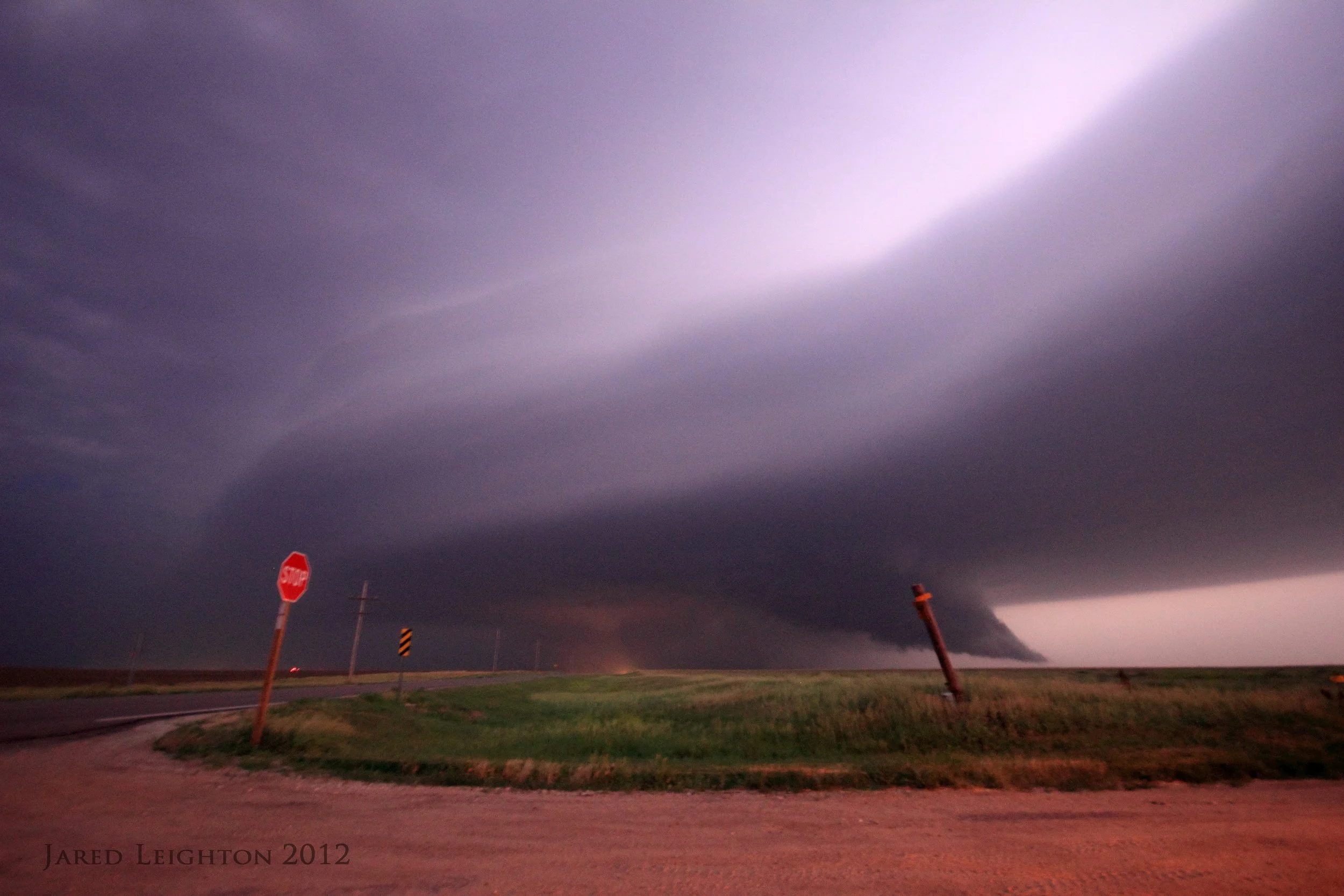
Left Lawrence, Kansas a little after 9:00 am on Sunday 18 March, 2012 with an initial target of Shamrock, Texas. As we headed west on Interstate 40 through Clinton and Elk City storms began firing around 3:00 pm along the dry-line east of Lubbock, Texas. Since storm initiation was about an hour earlier than was previously expected we needed to make quick decisions regarding the day’s strategy. After a quick driver switch in Elk City, Oklahoma we immediately went into intercept mode since the cells near Childress, Texas would likely become supercellular within the next hour. At that point we decided to ditch the original target of Shamrock, Texas and head south out of Erick, Oklahoma along Highway 30 to Hollis, Oklahoma. The target cell had just become severe thunderstorm warned once we started our southward movement. Once we arrived in Hollis the storm was strong, but not quite demonstrating any real organization. Our decision was to sit in Hollis and watch the storm move northeastward to our location. While we were in Hollis we witnessed the transformation of the storm from a typical single-cell to supercell as rotation became visibly evident, and a nice, sculpted, striated updraft took form. Given the storm’s north-northeastward movement of 30 to 35 knots we moved north about 5 miles and east about 3 miles to stay ahead of the storm. At this point numerous updrafts around the storm created some interference, which perhaps hindered its development. We needed to make our second critical decision of the day at this point. The cell about 50 miles south of our location was already supercellular, and tornado warned. One option was to leave our storm and make a play on the southern cell, while the other option was to stay with our cell and hope the mergers weren’t destructive. Due to forecast parameters being much more favorable for tornadoes later in the evening in our current location we decided to stay with our storm. Sure enough the mergers concluded, the storm survived, and morphed into a very strong supercell. Throughout its entire mature lifespan - roughly 5:00 pm through 8:00 pm - 40-50 mph inflow and impressive inflow bands demonstrated just how strong this storm actually was. We stair-stepped our way north-northeast a few times to stay ahead of the storm, and witnessed several cycles of its parent mesocyclones. The storm was fairly unique in that its mesocyclones occluded on a fairly frequent basis.
We witnessed our first tornado just east of Reed, Oklahoma as we were traveling east on Highway 9. A very long “elephant trunk” tornado crossed Highway 9 about two miles behind us, roughly 90 seconds after we were at the spot it crossed the highway. The tornado was rather brief in nature, and quickly dissipated. As we travelled north-northeast in our stair-step pattern we witnessed another very low hanging, wide funnel. We could not discern whether this was a true tornado or not, but photographic evidence from other chasers helped us conclude that it was indeed a tornado. Our second and final tornado occurred around 7:30 pm, and we witnessed it as we travelled north on Highway 6 about 5 miles north of Willow, Oklahoma. Since we had to make a large repositioning move, we found ourselves roughly 5 miles east of the storm at the time of this tornado, so we did not get a great look at it, but our vantage point gave us an unbelievable look at the overall storm structure, represented in the photographs. We followed the storm north on Highway 6 about 5 miles further and once we got our first burst of cold air from the storm we deemed it a decaying thunderstorm, and continued north to Interstate 40 and Elk City where we called off the chase.
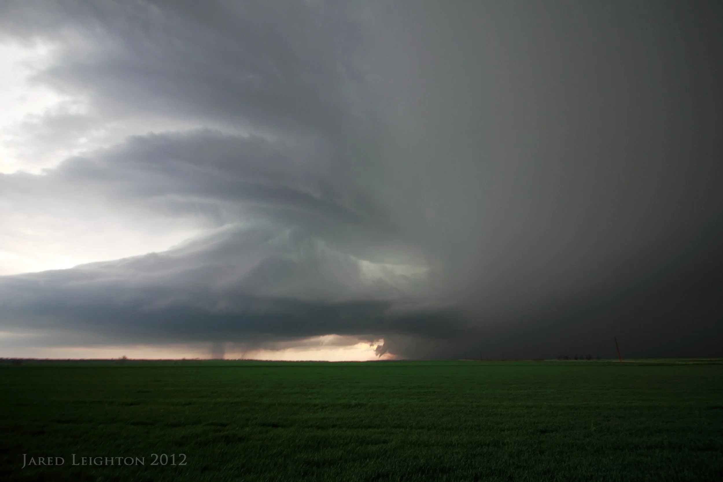
Once the supercell matured, it took on an amazing sculpted structure. Note the small elephant trunk tornado just to the left of the precipitation shaft.

Once the supercell matured, it took on an amazing sculpted structure.
Target: Northeast Kansas
Left Lawrence on an impromptu chase approximately 3:00 pm, and headed west on Interstate 70 to Junction City, Kansas. Convective initiation was expected around 4:30 to 5:00 in and around the McPherson, Kansas area. Instead nothing formed across Central Kansas. To our east, just southwest of Topeka, two storms fired up and moved northeastward toward Topeka. We left our post at Junction City to pursue the storms in Osage County. As we traveled east on I-70 we noticed that the storm wasn't intensifying quickly, nor was it moving very swiftly to the northeast. By the time we got south of Topeka the storm had not moved much to the northeast. We arrived to the storm about 5:30 pm and stationed ourselves under the updraft to catch photos and time lapse. Since the storm did not demonstrate much ability to become well organized we dropped south from our post near Carbondale to sample some of the hail. At an intersection along Highway 75 just south of Carbondale we sampled 2 inch hail. After the hail was over we drove north from our post and got off at Highway 56 and Highway 75 near Carbondale. There we observed the storm become the most orgainzed it would ever become. A very well defined RFD notch ate into the backside of the storm and caused the updraft to tighten up briefly, which brought on the only funnel cloud of the storm. At our post just east of Carbondale we were able to sample another swath of hail, this time up to 3 inches in diameter. The Carbondale storm quickly dissipated, so we focused our attention to a tornado warned storm 70 miles to our south. We jumped on Highway 75 to go south to Greenwood County, but noticed the great lightning show to our west with a tornadic storm in Lyon County. Due to the late hour, and our forecast that storms would quickly taper off we decided to end the chase near Lyndon, Kansas and spent an hour shooting lightning near a prescribed burn. This proved to be a good choice since I was able to take my best lightning photo to date. After an hour of shooting some lightning, we drove back to Lawrence.
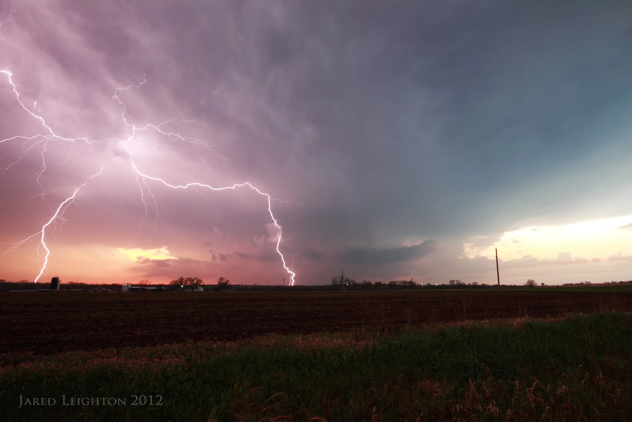
Called the chase off rather early on March 28 to take advantage of the spectacular lightning display.
Target: Altus, Oklahoma
Left Lawrence, Kansas around 9:30 with a preliminary goal to get to southwest Oklahoma. The exact location of initiation was a little uncertain, so flexibility was going to be needed. We transitioned from Interstate 35 to Interstate 44 with the intent to head west on Highway 62 toward Altus, Oklahoma. As we headed south on Interstate 44 we passed through some elevated convection that quickly became more organized to our north. We took a brief detour back to the north to see how the storms would develop. After a brief detour to the north, we continued our journey to the southwest. Incidently one of the developing storms became supercellular and produced a tornado in Norman, Oklahoma. Upon arriving to Altus the initial dryline supercell formed just west of town. We followed the storm northeast while it continued to develop. After developing some moderate rotation and a picturesque wall cloud north of Altus. This storm did not persist long and soon died near Blair, Oklahoma. The storms to the southwest underwent a few mergers and became supercellular after all the mergers were finished. Immediately the storm took on an HP appearance as a wet RFD came around the updraft of the storm. At this time I received word that a tornado was causing damage to the town of Blair, Oklahoma. As I watched the storm it was apparent that I would not see a tornado, due to the HP nature of the storm. So we took a jaunt to the east so we could get into a better road network. We stopped about 9 miles south of Cooperton, Oklahoma and watched the storm undergo a cyclic phase and become more organized. Upon realizing that we were on the western edge of the Wichita Mountains and no easterly route would be available we tried to beat the storm to Cooperton so we could head east. As we approached Cooperton the storm crossed our northerly route, effectively ending our pursuit. Before retreating to the south we witnessed another RFD swinging around the updraft and a very well defined and vigorous funnel appeared. Normally a funnel would not create much of a stir, but the motion and color of the storm was very remarkable. While watching the funnel we briefly stopped to speak with Bob and Rachel Fritchie on Highway 54. We decided to retreat south so we could find an easterly route through the Wichita Mountain State Park. This drive turned out to be very scenic with many longhorns and buffalo. In fact we almost hit a buffalo which was crossing the road in front of us. After stopping in the park for a few storm shots we resumed the chase and caught back up with the storm at the intersection of Highway 19 and 58 near Boone, Oklahoma. After shooting a few lightning pictures we decided to end the chase and head back to Interstate 44 at Chickasha, Oklahoma for our trip home. Ultimately this chase turned out well, as the scenery and storm structure were the highlights of the chase. Bad navigation, unhelpful road networks, and substandard photography definitely brought negatives to this chase.

Supercell near Roosevelt, Oklahoma
Target: Greensburg, Kansas
Left Lawrence shortly after getting off of a midnight shift at work. The original target for the day was Plainview, Texas, but due to the distance of the target I adjusted to a southwest Kansas target. Given the ample instability and shear parameters near Dodge City, Kansas and with hi-res short range models consistently showing deep convection in that area, I opted for the closer target near Dodge City. Left Lawrence shortly after getting off of a midnight shift, with the intent of getting to Greensburg and waiting for convection to initiate. Although storms initiated a little later than anticipated they fired up over Dodge City as expected. Picking an original storm was difficult, but one storm eventually became supercellular and possibly even produced a brief tornado near Dodge City. I arrived to the storm as it passed north of Dodge City and led it eastward until it approached Offerle, Kansas. At this time other cells started to become tornadic, so I dropped south from Kinsley, Kansas to another cell to the south. It quickly became undercut by outflow winds, signified by a cool gush of air from the direction of the storm. Although storms were still tornado warned I decided to disengage from the storms and negotiate my way eastward through the complex of tornadic storms. As I drove through the storms, they congealed into a complex and spread eastward into Wichita and Topeka. This allowed for an amazing lightning show for my entire trip home from southwest Kansas.

This supercell produced an RFD shelf over a windmill farm near Dodge City, Kansas
Target: Ogallala, Nebraska
May 18th marked the opening day of project HailSTONE. The group targeted Ogallala, Nebraska for marginal thunderstorm development. After sitting in the parking lot of Pamida in Ogallala for several hours, the group set out for some storms which fired up north of Ogallala. As the storms intensified the group spread out to the west in a picket fence fashion as a strong storm formed just southwest of Arthur, Nebraska. As the hail started falling on the group a dog took shelter under the car. The hail was large, but very soft. Each stone hit the ground and exploded into a slush ball. The hail seemed closer to large snowflakes rather than hail stones. After getting the dog out from under the car we left the area the get more data. We stopped nearly a mile down th road, only to have the dog rejoin us. Once again, the dog was removed, and we pushed back to the east, only to have the dog rejoin us. After 4 or 5 miles we finally shook the dog, and called off the chase. We ended up on the east side of Lake McConaughy to take some post chase lightning shots over the lake.
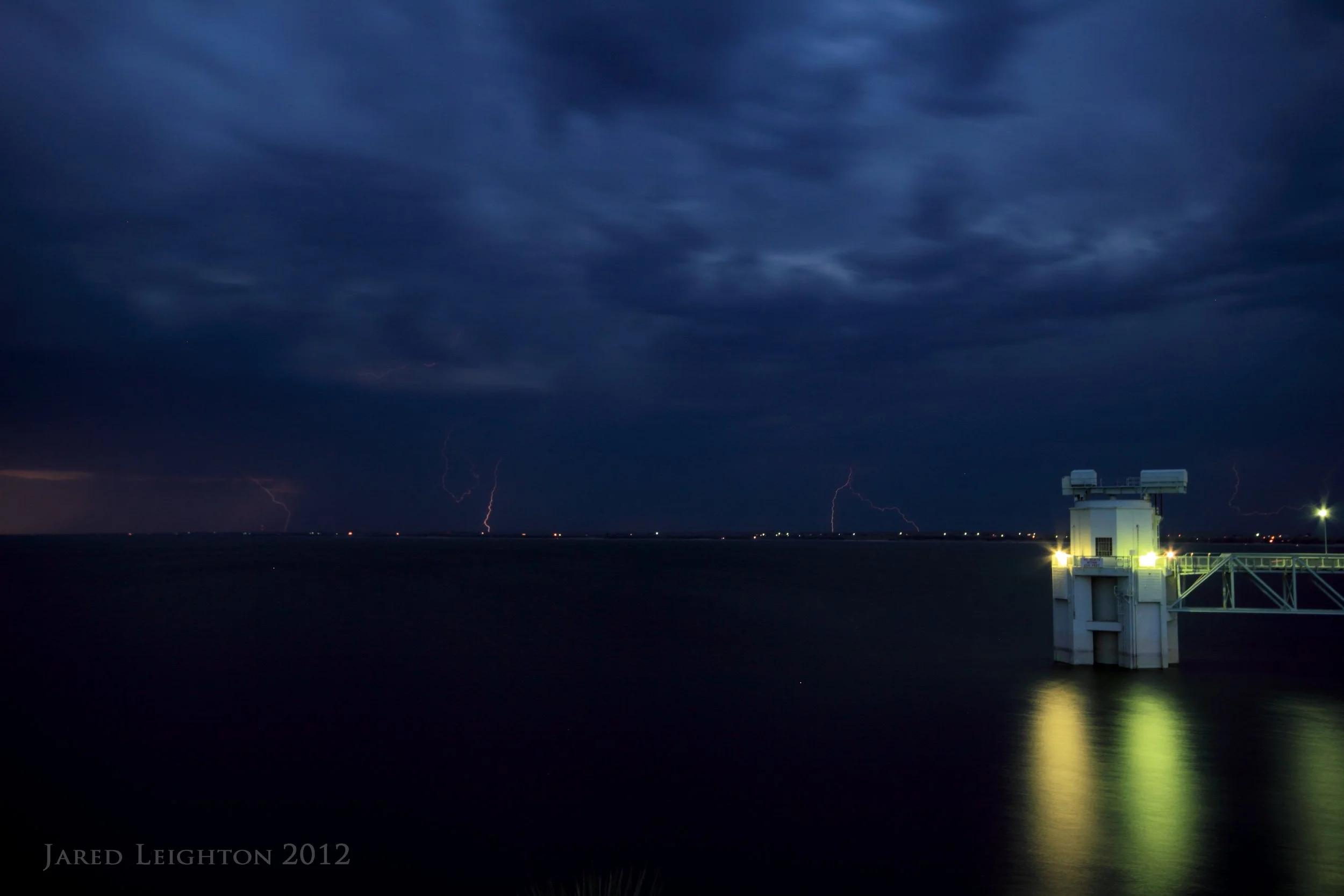
After the chase ended, we stopped at Lake McConaughy for some lightning shots.
Target: Greensburg, Kansas
The HailSTONE group left Colby, Kansas with the target of Greensburg, Kansas for afternoon convection. Given the strong instability and shear, this day was expected to yield good results for hail research. As the team entered Kinsley, Kansas storms initiated along the cold front, and quickly became severe. After a couple hours of getting into 2+ inch hail, the storms strangely and unexpectedly started producing tornadoes. The first one of the day was about 10 miles south of Arlington, Kansas, and was simply a wide funnel with a dust swirl underneath. It crossed Highway 14 in front of us before we got to Kingman, Kansas. As we entered into Kingman, another needle tornado formed just west of town, but quickly dissipated. We dropped south out of Murdock, Kansas, only to see another distant cone tornado, which was located near Rago, Kansas. This was our final witnessed tornado for that day. We ended the chase in Anthony, Kansas, and drove to Wichita for the night.
As we dropped south out of Murdock, Kansas, we witnessed a distant tornado to our southwest, near Rago, Kansas.
Target: Bismarck, North Dakota
After a long drive north out of Lawrence, we slumbered in Watertown, South Dakota the night before targeting Bismarck, North Dakota. Severe parameters were excellent for large-hail producing storms. We got into Bismarck around 2 pm, and waited for initiation just west of town before retreating to the east. Once it became obvious that storms were not going to fire in our primary target area, we targeted ongoing convection in N. South Dakota. We drove east on I-94 toward Jamestown as a fast-moving left mover moved north toward Jamestown. We peeled off the highway, taking some very questionable roads that alternated between dirt and pavement. The small lakes provided nice scenery, and the storms produced golf ball sized hail. We ended the chase south of Jamestown, and took a few lightning photos near Monango, North Dakota before heading back to Watertown for the night.

Explosive storm just south of Jamestown, North Dakota.
Target: Great Bend, Kansas
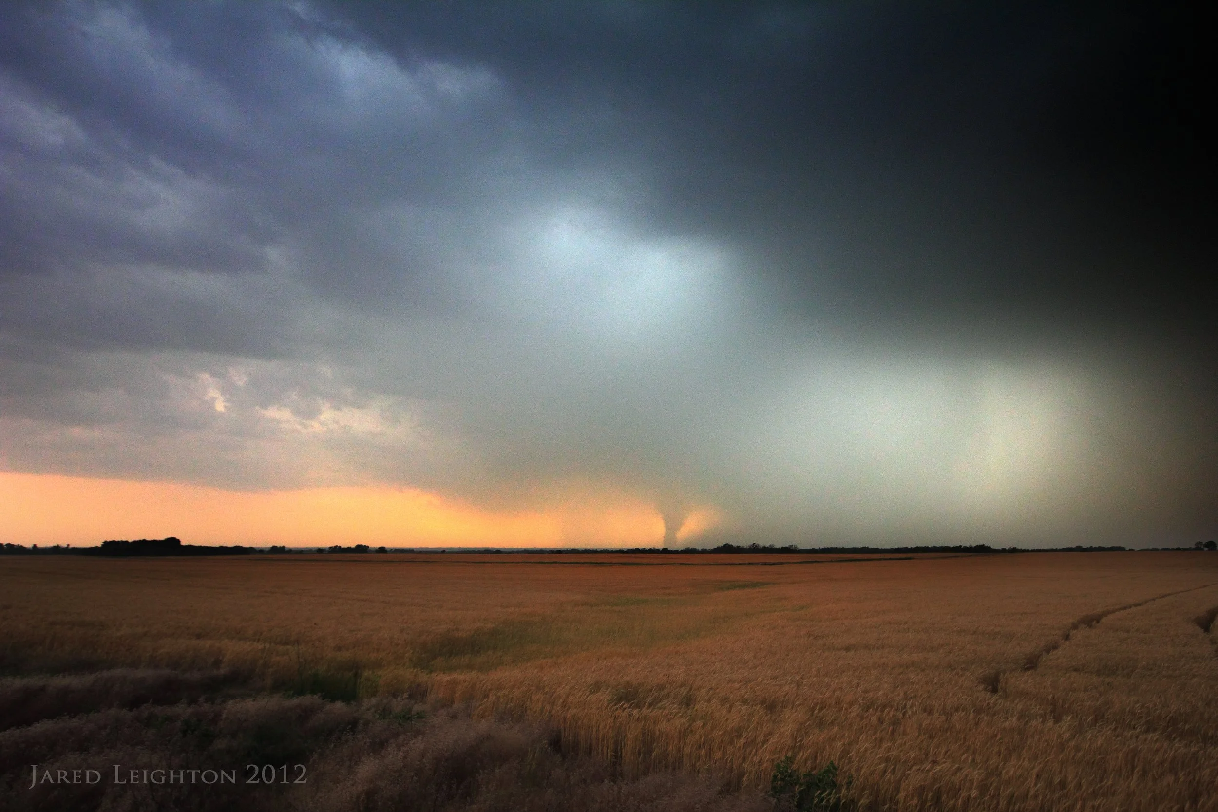
Departed Lawrence, Kansas around 1:00 pm with the intent to get to Great Bend, Kansas. Met up with Josh Boustead and Derek Deroche west of Great Bend about an hour before initiation. The first storm fired up near Rush Center, Kansas around 5:30 pm, and moved northeast toward the interstate. We pursued that storm until it seemingly crossed the warm front near Interstate 70. Along its path its RFD outflow winds caused a lot of dust to be kicked up, resulting in numerous erroneous tornado reports. We decided to leave that storm and drop south to the next storm in the line, which looked somewhat interesting. We spent a short time with that storm before moving to the southern-most storm in the line, which also demonstrated the best structure. We stopped east of Lacrosse on Highway 4, and watched the storm become organized, over a 30 to 40 minute period. Finally around 9:30 pm it produced a tornado about 2 miles southwest of our location. We watched the tornado for about 5 minutes before retreating to the east. We moved about 3 miles east (1 mile west of Lacrosse), and watched it cross the road at our previous location. We then pushed another 10 miles east of Lacrosse and emerged from under the updraft of the storm, only to reveal its striated structure. While photgraphing the structure we noticed that it was producing multiple vortices in the field west of our location (NE of Lacrosse). While we were watching the storm it produced another large cone tornado NE of Lacrosse. It produced 2 more tornadoes north of our location, but due to its distance from us we did not get great looks at the tornado, other than to see a power flash north of our location. We ended the chase around 11:30 pm, and headed to Salina for post chase dinner.

Another large cone tornado formed in the field northeast of Lacrosse, Kansas

Wall cloud backlit right before producing a large tornado just west of Lacrosse, Kansas
The lightning lit up the striated structure of the supercell that spawned all the tornadoes near Lacrosse.
Target: Hays, Kansas
Left Lawrence, Kansas around 1:30 pm with Scott Blair intending to get to Hays, Kansas. It became very evident early in the wait for initiation that the storms would not be as robust as initially expected. The storms were very high based, and simply could not realize the CAPE that was present. We ended up chasing behind a left moving storm, which produced 2+ inch hail south of Hays and documenting spiked hail north of Hays. We watched one LP supercell occlude directly overhead, which offered a unique view into the supercell structure. We ended the day south of Ellis in a field taking photos of the backside of a weak supercell, which put on a memorable mammatus display.
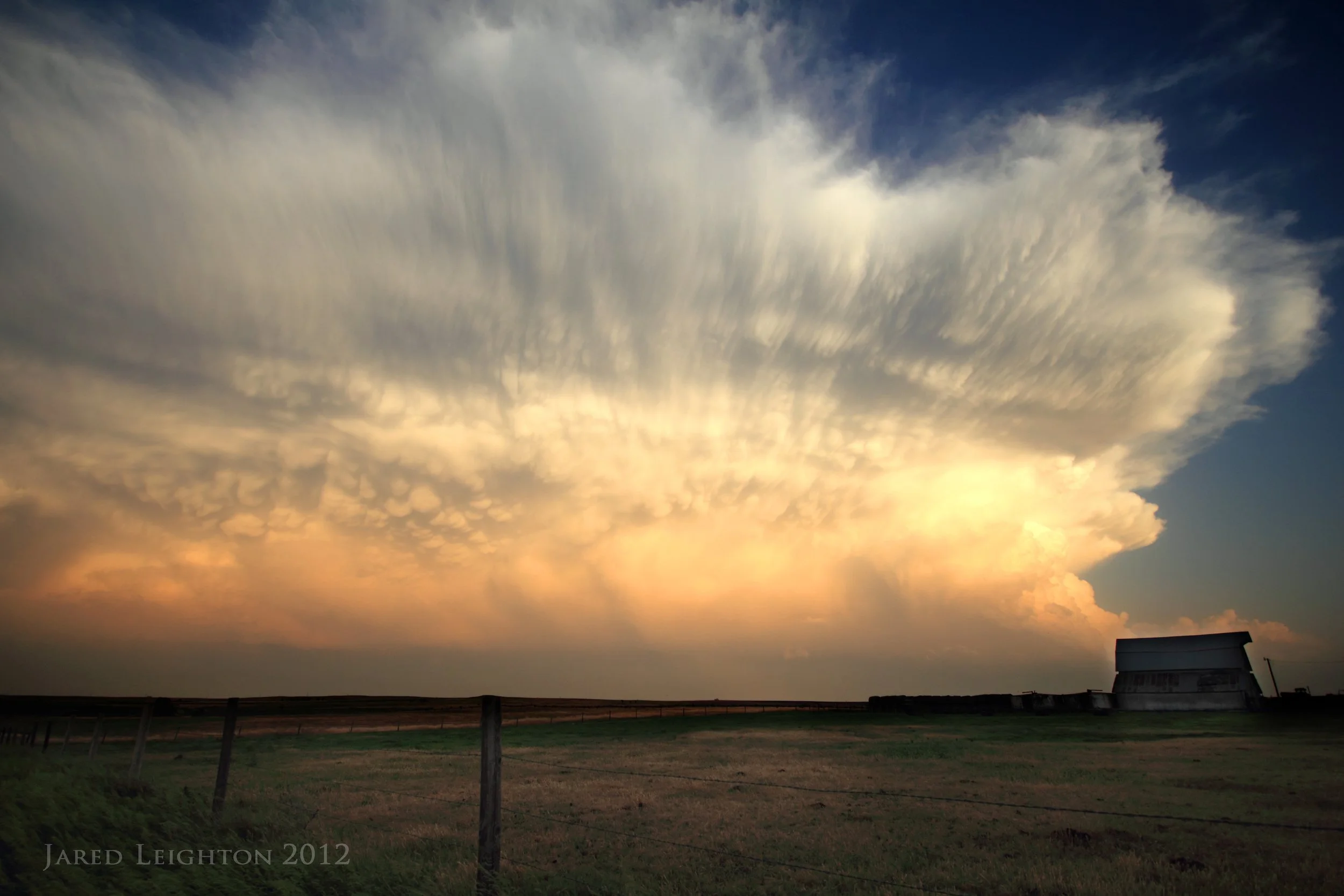
A distant storm put on a memorable mammatus display near Hays, Kansas
Target: Clovis, New Mexico
Left Lawrence, Kansas with Josh Boustead around 6:00 am with the intent of getting to the western Texas Panhandle early that afternoon. Given the strong upslope flow and good zonal mid level flow we figured a supercell or two would be likely somewhere in far eastern New Mexico. We eventually targeted the area of Clovis, New Mexico and waited for convection to occur. A discreet cell formed around 5:30 pm MDT between Santa Rosa, NM and Fort Sumner, NM. The storm took a while to get organized, but around 7:30 pm it rapidly intensified into a robust supercell. We followed the storm southeastward to Melrose, NM then dropped south of town on Highway 267. By this time the storm had become very organized and formed an RFD slot. It looked as though it would form a tornado at that point, but likely due to the higher than optimal T-Td spread it was unable to form one. We stayed south of the storm as it took a hard right turn to the south-southeast. Once we got to Portales, NM we called the chase off due to darkness. We suspected the storm was still very strong and producing large hail, and maybe even a tornado so we travelled well west of the storm before heading north behind it. The storm did go on to produce 4-5 inch hail in Melrose and a couple tornadoes near Floyd and Dora. We finished the night between Melrose and Clovis shooting some lightning on the back side of the storm.

The supercell near Clovis, NM presented a unique display of collar rings around the updraft