

Chase 2011
Target: Northeast Kansas
Caravanning with Scott Blair we left Lawrence, Kansas approximately 5:30 pm on April 3rd to target a cell which was quickly demonstrating supercell characteristics on radar. We stopped between Topeka and Lawrence to get a good look at the well defined updraft column and its associated anvil. After continuing west on Interstate 70 we reached the updraft as it continued its eastward motion. We followed the storm back to the east then jolted north on Highway 4 to Highway 24 where we drove eastward. It was on Highway 24 between Topeka and Lawrence that we witnessed a very strong gustnado. This feature formed just to our south on the south side of Highway 24. It started out as an unassuming dust cloud, but it shortly took on a swirling structure. As we continued eastward we passed the structure in its infancy, but as we looked behind us we could see that it was growing in strength and size. When Highway 24 took a brief southern turn we got a great view of the developing gustnado. During this southern fetch I was able to get the above photos. After approximately 10 minutes of life the dust swirl finally dissipated. We followed that cell to Bonner Springs with little excitement, so we left the cell and headed back to Lawrence. I met up with Scott Blair in North Lawrence before dropping south out of Lawrence to sample as much hail as we could in the remaining time we had. By 9:00 pm we received 1.50" hail near Pleasant Grove, and around 9:30 we saw 1.50" hail one mile south of Princeton, KS. Since it was getting late in the evening we decided to finish the chase and head back to Lawrence.

The first cell of the day as it was beginning to morph into a very strong supercell. This photo was taken between Topeka and Lawrence while the cell was between Manhattan and Topeka.
Target: Ponca City, Oklahoma
We left Lawrence around 2:30 pm and headed south along Interstate 35 to El Dorado. From there we traveled southward on Highway 77 to Ponca City, Oklahoma. Storms fired off the dryline which was situated west of highway 35. Two cells formed in north central Oklahoma. Our choice was to follow the eastern cell, which was heading straight for our location in Ponca City. Just west of town the storm became a supercell, took a right turn, and followed a more easterly direction. While we watched the cell move west to east just north of our location an RFD slot cleared its way through the back side of the cell. At that point the wall cloud associated with our storm began to rotate vigorously. As the RFD wrapped around the updraft the wall cloud became very stretched and elongated. I half expected a tornado to form at this point, but the organization the storm was demonstrating soon dissipated. We followed Highway 2 westward out of Ponca City toward Kaw City watching the northern sky to see if it would re-organize. As we traveled eastward along Highway 2 we saw that the storm was forming another lowering. Due to the hazy conditions and the 3 to 5 mile distance between us and the storm our view of the lowering was not optimal. It was apparent however that the storm did produce a very brief shallow funnel. This brief funnel would be the unfortunate end of the storm as it quickly dissipated soon thereafter. With darkness looming we ended the chase and drove northward toward Topeka.

Shortly after the RFD wrapped around the updraft the wall cloud became stretched. The rotation was extremely vigorous at this point. A tornado seemed imminent, but it never occurred.
Target: Medicine Lodge, Kansas
This day commenced the HailSTONE project, which was intended to last from May 19 through May 24th. Scott Blair, Jenni Laflin, and we started from Lawrence, Kansas around 7:30 am, with the intent of meeting Derek Deroche in Ottawa, Kansas before heading to Medicine Lodge. The first storms of the day fired early in western Oklahoma, but due to the distance to the storms we decided not to chase them and wait for later initiation in southern Kansas. Around 3 pm storms fired near Coldwater, Kansas, so we made our way to intercept the new storms. Within 15 to 30 minutes of their formation they quickly collapsed leading to a wet downburst situation near the core of the storm. The next strong storm followed suit by collapsing and bringing 60 to 70 mph winds along with a torrential downpour to the town of Greensburg. After waiting in Greensburg for over and hour for the next storm to initiate, we caught our first glimpse of a new updraft to our southwest. We left our location in Greensburg to go after the new storm, but by the time we arrived it had quickly weakened. We took the opportunity to get some photos of the picturesque storm and decided to reposition to the next day's target in Woodward, Oklahoma.

Distant Supercell near Coldwater, Kansas
Target: Ada, Oklahoma
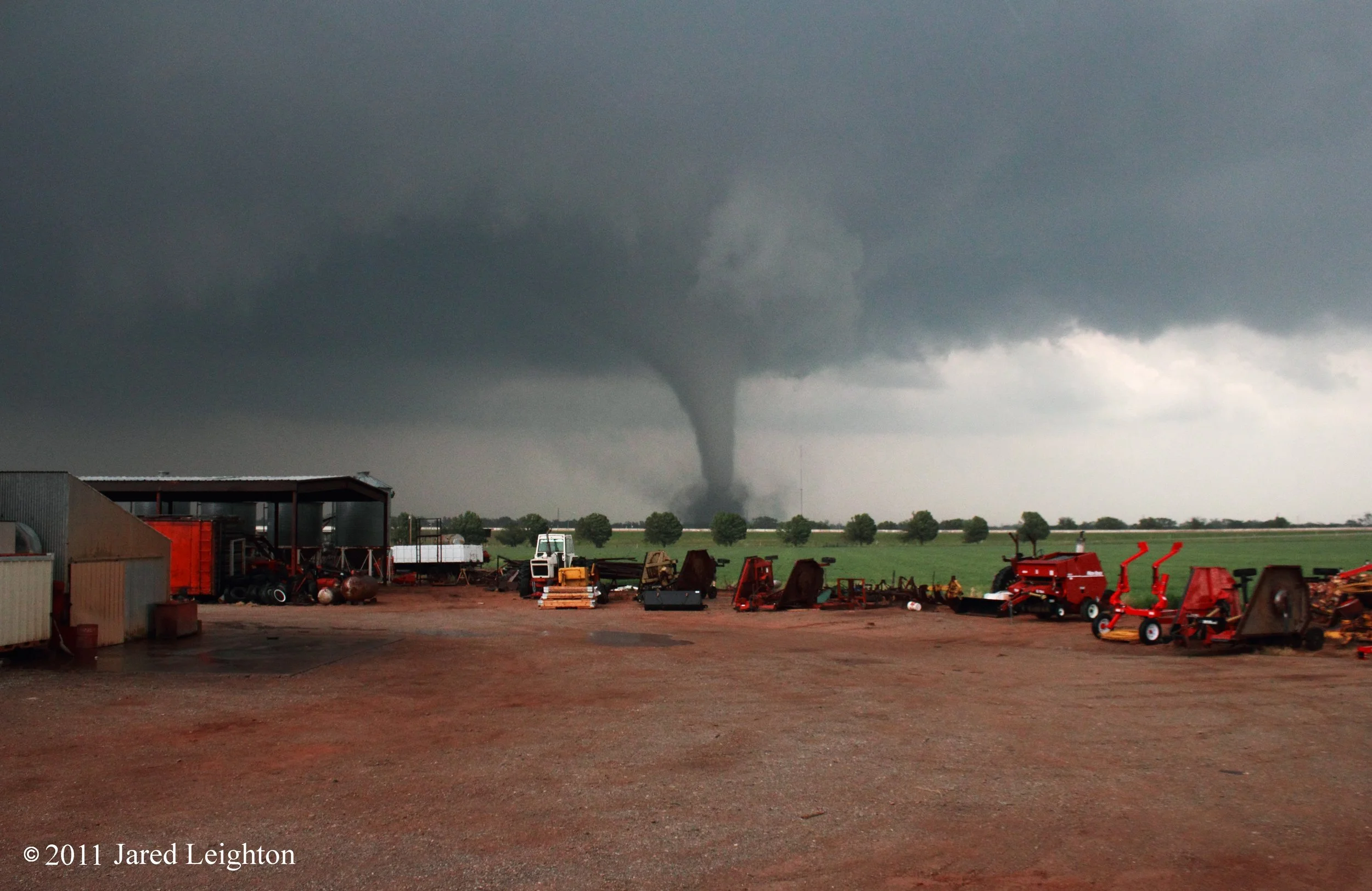
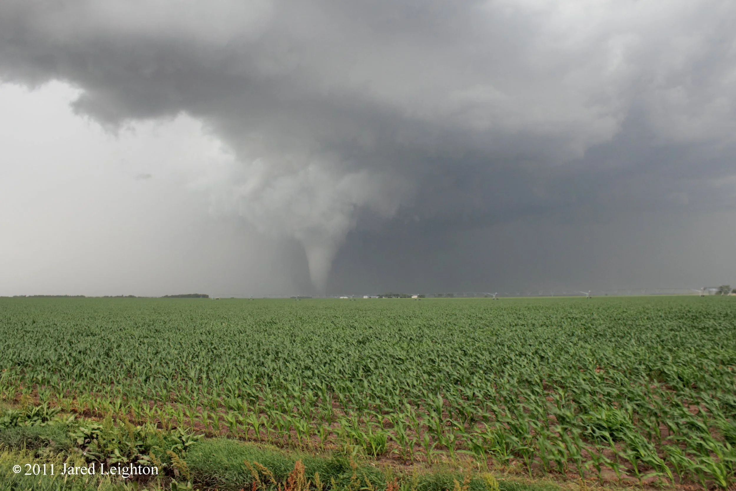
After the storm-less day on May 20, the convoy overnighted in the town of Perry, Oklahoma. The original target for this day was northeast Kansas - in the Topeka/Lawrence area. But after some careful consideration the convoy changed the target to south central Oklahoma. Although the Kansas target looked a little more likely to initiate, the shear and instability parameters looked a little better in Oklahoma. And since large hail was the objective of the project the target with higher instability was chosen. Initiation finally took place late in the day west of Ada, Oklahoma. The storm quickly turned into a supercell and demonstrated signs that it was about to produce a tornado. While waiting for the storm to reach my destination the storm produced a tornado, which was visible from my position nearly 3 or 4 miles away. The convoy quickly raced east to stay ahead of the storm, and while we were repositioning we could see the storm's amazing supercellular structure. We pushed north back to Ada, and waited for the storm to move through the city. As it crossed Highway 99 north of Ada the HailSTONE group collected numerous hail stones, which proved very valuable to the objective of the project. Darkness quickly settled in and the team disengaged from the storm in Allen, Oklahoma. The rest of the team stayed in Tulsa, but because we had to drop off a member of the team in Lawrence, I travelled home that night, and rejoined the team the next day in Tulsa, Oklahoma.

Structure of the supercell which spawned a couple brief tornadoes near Ada, Oklahoma.
Target: Joplin, Missouri
May 22, 2011 will be a day that lives with me for a long time. The day started out so unassuming. The HailSTONE project was well on its way, and since I had to travel to Lawrence the previous night I started early to rejoin the group. The original idea was to move southward from the overnight lodging spot of Paul's Valley, Oklahoma to north central Texas. As I approached Perry, Oklahoma I received word that the target would be southeast Kansas. So I casually drove to Sepulpa, Oklahoma to wait for the rest of the group to arrive. After a brief lunch and gas stop in Sepulpa the convoy pushed to the northeast to begin the chase in southeast Kansas. Upon arriving in Columbus, Kansas the first storms of the day initiated west of our location. They quickly became strong and demonstrated characteristics conducive of large hail. So we went to intercept the storms west of our location. Before we could intercept more updrafts formed and congealed into a multicellular complex of storms. As we followed the storms to the east they became more organized into a single supercell. Due to our position to the north of the storm we did not see the tornado which was quickly forming on the rear flank of the storm. We continued to collect hail stones unaware that the tornado just a couple miles to our south was obliterating the city of Joplin, Missouri. Reports from other group members indicated that parts of Joplin were damaged, but the overall scope of the devastation would not be known until much later. The group continued the chase - unaware of the calamity that befell Joplin - through the winding roads of southwest Missouri, crossing the path of the tornado multiple times. A line of semi trucks was toppled over on Interstate 44 near Joplin and the town of Wentworth was nearly destroyed. We finished the chase in Neosho, Missouri after intercepting multiple storms and collecting a robust data set. As we talked about the chase and the data we collected reports of the true devastation that Joplin encountered began filtering into the group. Teaming up with Mike Mezeul we entered the town of Joplin about two and a half hours after the storm tore through the center of town. The two hours in Joplin were two hours that I'll never forget. The scene was extremely dark, since the sun had long since set and power was out to most of the city. As we approached the damage path it became more evident that this was a catastrophic event. The amount of damage in itself was horrific enough, but the victims of the storm walked down the street in shock of what had happened. They didn't make eye contact, but looked straight forward with mouths agape. They walked aimlessly down the streets with no urgency and no expression. The sight of the damage was complimented with the smells of fresh timber, dirt, and natural gas. Many of the houses we walked passed had a strong and audible hissing as unchecked natural gas leaked from the severed pipes. Adding to the disturbing scene was the large number of abandoned vehicles. Many of the vehicles were deposited in place by the tornado, but many of them were left by their owners where they rested. After two hours of walking through a couple neighborhoods we left the city and rejoined the HailSTONE group in Tulsa, Oklahoma.

Made a visit to Joplin, Missouri on July 15, 54 days after the tornado. Although some lots were cleared off and some businesses were rebuilt, there was still a lot of work to be done.
Target: Apache, Oklahoma
The HailSTONE convoy started the day in Tulsa, Oklahoma and set out for southwest Oklahoma early on May 23. Given the high shear and instability parameters in southeast Oklahoma the squad favored that area for the formation of giant hail. After solving some data acquisition issues, thanks to Bart Comstock, we were able to target a storm which showed some promise near Apache, Oklahoma. We were instructed to hold at an intersection near Gotebo, Oklahoma and wait for the storm to move east. As we waited I heard a faint whirring noise followed by a loud splat. Quickly I surmised that although we were a good two to three miles south of the main updraft we were being targeted by errant four to five inch hail stones. Even after another bump to the south to avoid the stones we were still under attack by sporadic five inch hail stones. Finally when we got enough nerve to move north and collect the hail we were fortunate enough to be able to see and hear the copious amount of giant hail stones fall in the field to our east. The oft used term "herd of running buffalo" sound emanated through the field as thousands of giant hail stones impacted the earth. The stones were also visible as they fell against the dark green back drop of a grove of trees about a mile into the field. At this point, we decided to start collecting stones. Mike Mezeul and I got out of the car to collect the enormous stones when I heard that familiar whirring noise again. After a loud expression from Mike I realized that the stone had landed less than ten feet from where he was collecting...a close call indeed. Calls then came over the radio to get to where the impact team was operating, as they were receiving larger hail than any of us had ever seen. Unfortunately by the time we arrived onto the scene the stones underwent some melting and were only a fraction of the size they were when they fell. Once the storm weakened below the levels it was performing at earlier in the day we called off the chase and met at a Fina gas station to use their walk-in freezer to analyze and measure the collected stones.
Follow-up: It was determined by National Climatic Database Center that the 6" hailstone collected by HailSTONE near Gotebo, Oklahoma on May 23, 2011 set an Oklahoma state record for largest diameter hailstone.
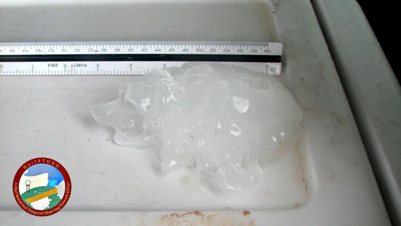
Photo of the 6" record hail stone collected by HailSTONE. Photo by Bart Comstock

Holding just a few of the enormous hailstones that we collected near Gotebo, Oklahoma. Our group, HailSTONE was able to collect the Oklahoma state record hail stone that day.
Target: Oklahoma City, Oklahoma
May 24, 2011 was to be the final day of organized operations for the HailSTONE project in 2011. The group started in Norman, Oklahoma and after lunch at Raising Canes in Norman, the convoy dropped southwestward back to Apache, Oklahoma. The first cell of the day initiated near Apache, but due to the storm motion the convoy ended up very close to Interstate 40 and the droves of chasers. As the storm moved over Lookeba, Oklahoma it developed a wedge tornado, which went on to destroy parts of El Reno and Piedmont, Oklahoma. We left the storm as it went into Lookeba and targeted a cell to the south as it went into Chickasha, Oklahoma. As we started hail collection operations the storm demonstrated quick organization and was expected to go tornadic shortly thereafter. Due to safety issues associated with violent tornadoes we called off the HailSTONE operations for the day, and went into tornado chase mode. Mike Mezeul and I met up with Scott Blair, Jenni Laflin, Chris Dobbs, and Derek Deroche at a tractor yard on the east side of Chickasha. As we got in view of the funnel cloud it created a dust swirl on the ground, which eventually grew in size. As the tornado crossed the field about a half mile away from us, it developed a condensation funnel all the way to the ground. The tornado then crossed Interstate 44 east of Chickasha and continued to the northeast. Mike and I left the tractor yard and entered the turnpike (I-44). We followed Derek and Chris northeast on the turnpike, paralleling the tornado to its northeast. As we drove on the turnpike we could see the tornado gain strength and intensity until it became a wedge tornado. We occasionally lost visual of the tornado as we traveled, but we felt we were ahead of it enough to remain safe. Once we reached the H.E. Bailey Turnpike Spur (Highway 9), we went east through raining debris. Once we reached the tornado path we stopped to help people who were emerging from the rubble of their apartment complex on the south side of Blanchard, Oklahoma. A look to the south gave us a glimpse of the 1/2 mile to 1 mile wide damage path. Once all people were out of the rubble and emergency personnel arrived we continued south to meet up with Scott and Jenni. At that point we ended the chase, and headed home to Lawrence.

Tornado just east of Chickasha, Oklahoma.
Tornado crossing I-44 just east of Chickasha.

The tornado took on a wedge appearance just before it entered the city of Blanchard, Oklahoma.
Target: White City, Kansas
An impromptu local chase started about 7 pm, when I left Lawrence, KS to target a developing storm near Abilene, Kansas. After getting some help and direction from Josh Boustead I caught up with the storm shortly after it produced a brief tornado. Although the storm didn't produce a tornado while I was watching it, the storm had some of the best structure I've ever seen. Within five to 10 minutes of my arrival to the storm it took on an LP structure, which provided even better view of the striated updraft of the storm. Quickly the storm weakened, and within 30 minutes of my arrival the storm had completely dissipated.

Supercell near White City, Kansas
Target: York, Nebraska
Well I sort of lied. The original target was not York, Nebraska, but was instead Columbus, Nebraska. I woke up late after working midnight shifts, and figured I'd have a couple hours to forecast the day's activities before departing for my target of Columbus, Nebraska. I departed Lawrence, Kansas around 12:30 pm and noticed convection was ongoing in northwest Kansas, well off to my west. That scenario perplexed me, as I figured the tornadic action would take place north of Interstate 80, near my original target of Columbus, Nebraska. As I was traveling north along highway 75 through northeast Kansas I noticed that one of the cells coming out of north central Kansas had become tornado warned and had many reports of large tornadoes. Quickly I determined that the target for the day had shifted southwest...about 150 miles. So I altered my course to go west through Lincoln, Nebraska, then west along Interstate 80. Not only was my spatial target off by about 100 to 150 miles, but convection started much earlier than I was prepared to intercept. So I found myself about 150 miles too far east and about 2 hours behind. To add to the agony, due to road construction and poor navigation, I encountered a significant delay in Lincoln. Finally, I emerged from Lincoln and jetted west on Interstate 80 toward Hastings. As I approached York, I could see on radar that the Hastings area storms were merging and creating a non-picturesque mess. I was no longer interested in targeting that storm, and stopped in York, Nebraska to refuel and reassess my strategy for the day. Although storms had been ongoing for hours and were no longer any good to look at, it was still only 4:00 pm. Surely, there was plenty of time in the day for more storms to fire and possibly become tornadic. As I sat at the gas station in York, I saw on radar that new storms were firing between Hebron and York, just to my south. Although it was a broken line of storms I figured the eastern edge of the convection could possibly become a tail-end Charlie and become the dominant storm. I decided to drop south out of York and intercept the eastern edge of the line of storms. Before I reached the exit of the gas station I saw a funnel lower from the storm I was then targeting. So instead of dropping south, I took a county road westward and paralleled the interstate to the south. Before the storm crossed the interstate it dropped another brief tornado which quickly dissipated. I crossed the interstate on Road H, and ran about 3 or 4 miles north and waited for the storm to reorganize. Since the storm motion was predominantly northerly, it moved parallel to the road I chose to follow it. As the storm passed by me, about two miles into the field I was stopped at the next funnel appeared and quickly developed a debris swirl on the ground...TORNADO. The condensation funnel slowly lowered to the ground, but the dirt and debris had completely enveloped the tight funnel. Within about five minutes the condensation funnel completely reached the ground and turned into a very large tornado. I let the storm get in front of me so I could get a perspective of the tornado from behind the storm. Once the storm got about three to five miles north of me it took on a brilliant white appearance all the while the RFD notch had completely encased the tornado. These features provided for extremely fascinating and aesthetically pleasing visuals of the tornado and the parent storm. After approximately 20 minutes on the ground the tornado roped out and quickly dissipated. I tried to follow the storm northward, but its motion quickly sped up to around 55 miles per hour. Given the fact that only gravel roads were available to me I could not keep up with the storm; although I did catch a glimpse of a third tornado that the storm produced near Stromsburg. It turned into an HP storm about the time I caught back up to it, and since the storms were merging into a QLCS, I figured it was time to head home. I dropped south back to York, along the way crossing the tornadoes' damage paths and witnessing some significant damage to houses, farms, and trees. I followed Highway 81 south out of York to Interstate 70, then followed I-70 all the way back to Lawrence witnessing about 2.5 hours of brilliant, long-lasting, anvil crawling lightning.

Structure of the supercell and tornado which formed near York, Nebraska.
The tornado took on a brilliant white coloration as it formed into a large cone.